ملف:Territory Of The German Military Commander In Serbia 1941-44.png
حجم هذه المعاينة: 474 × 599 بكسل. البعد الآخر: 500 × 632 بكسل.
الملف الأصلي (500 × 632 بكسل حجم الملف: 99 كيلوبايت، نوع MIME: image/png)
وصف قصير
| ⧼wm-license-information-description⧽ |
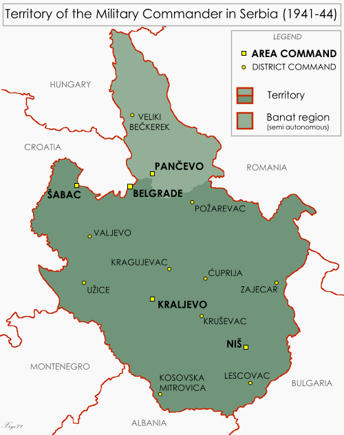
English: Map of the Territory of the German Military Commander in Serbia. Showing area and district commands and the Banat autonomous region.
|
| ⧼wm-license-information-date⧽ | 2012 |
| ⧼wm-license-information-source⧽ | ⧼Wm-license-own-work⧽, drawn from Serbia - June 1944 1:2M MDR Misc 8380, Survey Directorate, Middle East (1944) and Volkstumkarte Jugoslawien 1:200k, Wilfried Krallert, Publikationsstelle Wien (1941) |
| ⧼wm-license-information-author⧽ | XrysD |
ترخيص
|
تاريخ الملف
اضغط على زمن/تاريخ لرؤية الملف كما بدا في هذا الزمن.
| زمن/تاريخ | صورة مصغرة | الأبعاد | مستخدم | تعليق | |
|---|---|---|---|---|---|
| حالي | ★ مراجعة معتمدة 05:32، 19 ديسمبر 2023 | | 500 × 632 (99 كيلوبايت) | Pastakhov (نقاش | مساهمات) | Upload https://upload.wikimedia.org/wikipedia/commons/8/88/Territory_Of_The_German_Military_Commander_In_Serbia_1941-44.png |
لا يمكنك استبدال هذا الملف.
وصلات
لا يوجد صفحات تصل لهذه الصورة.