ملف:Tauber catchment.png

حجم هذه المعاينة: 634 × 600 بكسل. البعد الآخر: 1٬200 × 1٬135 بكسل.
الملف الأصلي (1٬200 × 1٬135 بكسل حجم الملف: 1٫11 ميجابايت، نوع MIME: image/png)
وصف قصير
| ⧼wm-license-information-description⧽ |
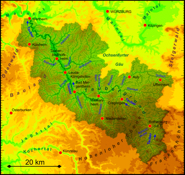
Deutsch: Einzugsgebiet der Tauber
English: Catchment area of the Tauber river
|
| ⧼wm-license-information-date⧽ | 2018 |
| ⧼wm-license-information-source⧽ | ⧼Wm-license-own-work⧽ |
| ⧼wm-license-information-author⧽ | Periphrastika |
Own work based on ASTER Digital Elevation Model data by https://lpdaac.usgs.gov/ and own runoff calculation
ترخيص
|
تاريخ الملف
اضغط على زمن/تاريخ لرؤية الملف كما بدا في هذا الزمن.
| زمن/تاريخ | صورة مصغرة | الأبعاد | مستخدم | تعليق | |
|---|---|---|---|---|---|
| حالي | ★ مراجعة معتمدة 06:59، 3 ديسمبر 2023 | | 1٬200 × 1٬135 (1٫11 ميجابايت) | Pastakhov (نقاش | مساهمات) | Upload https://upload.wikimedia.org/wikipedia/commons/f/f8/Tauber_catchment.png |
لا يمكنك استبدال هذا الملف.
وصلات
لا يوجد صفحات تصل لهذه الصورة.