ملف:Tahalra.jpg
لا توجد دقة أعلى متوفرة.
Tahalra.jpg (640 × 396 بكسل حجم الملف: 127 كيلوبايت، نوع MIME: image/jpeg)
وصف قصير
| ⧼wm-license-information-description⧽ |
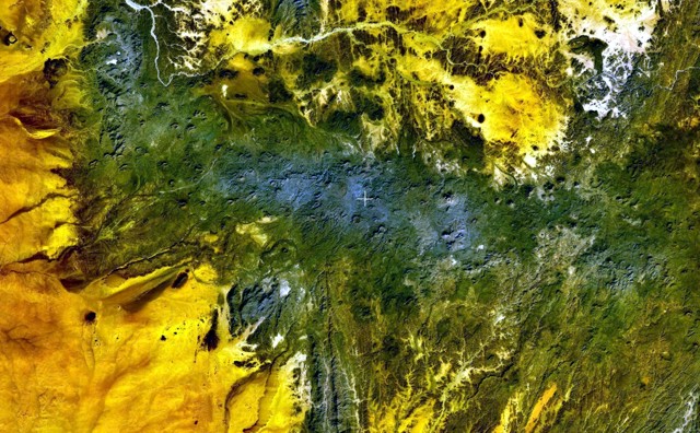
English: The dark-green and bluish-gray areas extending across this NASA Landsat image depict the elongated, E-W-trending Tahalra volcanic field, which covers an area of about 1800 sq km in the Hoggar Province of southern Algeria. About 100 small strombolian basaltic cones formed during the Pliocene and Pleistocene, and the most recent activity during the late-Pleistocene and Holocene produced about 20 maars and cones along the northern margin of the volcanic field.
|
| ⧼wm-license-information-date⧽ | تاريخ غير معروف |
| ⧼wm-license-information-source⧽ | http://www.volcano.si.edu/world/volcano.cfm?vnum=0205-004&volpage=photos&photo=119026 |
| ⧼wm-license-information-author⧽ | NASA Landsat7 image (worldwind.arc.nasa.gov) |
ترخيص
تاريخ الملف
اضغط على زمن/تاريخ لرؤية الملف كما بدا في هذا الزمن.
| زمن/تاريخ | صورة مصغرة | الأبعاد | مستخدم | تعليق | |
|---|---|---|---|---|---|
| حالي | ★ مراجعة معتمدة 11:33، 13 ديسمبر 2023 | | 640 × 396 (127 كيلوبايت) | Pastakhov (نقاش | مساهمات) | Upload https://upload.wikimedia.org/wikipedia/commons/0/07/Tahalra.jpg |
لا يمكنك استبدال هذا الملف.
وصلات
لا يوجد صفحات تصل لهذه الصورة.