ملف:Tafu-Maka.jpg
لا توجد دقة أعلى متوفرة.
Tafu-Maka.jpg (430 × 480 بكسل حجم الملف: 89 كيلوبايت، نوع MIME: image/jpeg)
| ⧼wm-license-information-description⧽ |
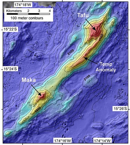
English: A bathymetric map prepared during a NOAA Vents Program November 2008 expedition shows two submarine volcanoes, Tafu (Tongan for "source of fire") and Maka (Tongan for "rock"). The volcanoes lie along a NE-SW-trending ridge on the southern part of the back-arc NE Lau Spreading Center (NELSC). The November 2008 expedition discovered submarine hydrothermal plumes consistent with very recent (days to weeks?) submarine lava effusion from Maka volcano.
|
||
| ⧼wm-license-information-date⧽ | 2008 | ||
| ⧼wm-license-information-source⧽ | http://www.volcano.si.edu/world/volcano.cfm?vnum=0403-12-&volpage=photos&photo=121006 | ||
| ⧼wm-license-information-author⧽ | NOAA Vents Program | ||
| ⧼wm-license-information-permission⧽ (⧼wm-license-information-permission-reusing-text⧽) |
|

تاريخ الملف
اضغط على زمن/تاريخ لرؤية الملف كما بدا في هذا الزمن.
| زمن/تاريخ | صورة مصغرة | الأبعاد | مستخدم | تعليق | |
|---|---|---|---|---|---|
| حالي | ★ مراجعة معتمدة 12:44، 10 أكتوبر 2023 | | 430 × 480 (89 كيلوبايت) | Pastakhov (نقاش | مساهمات) | Upload https://upload.wikimedia.org/wikipedia/commons/4/41/Tafu-Maka.jpg |
لا يمكنك استبدال هذا الملف.
وصلات
لا يوجد صفحات تصل لهذه الصورة.