ملف:TRANS-MISSISSIPPI CIVIL WAR.svg

حجم معاينة PNG لذلك الملف ذي الامتداد SVG: 750 × 600 بكسل. البعد الآخر: 2٬560 × 2٬048 بكسل.
الملف الأصلي (ملف SVG، أبعاده 1٬500 × 1٬200 بكسل، حجم الملف: 133 كيلوبايت)
وصف قصير
| ⧼wm-license-information-description⧽ |
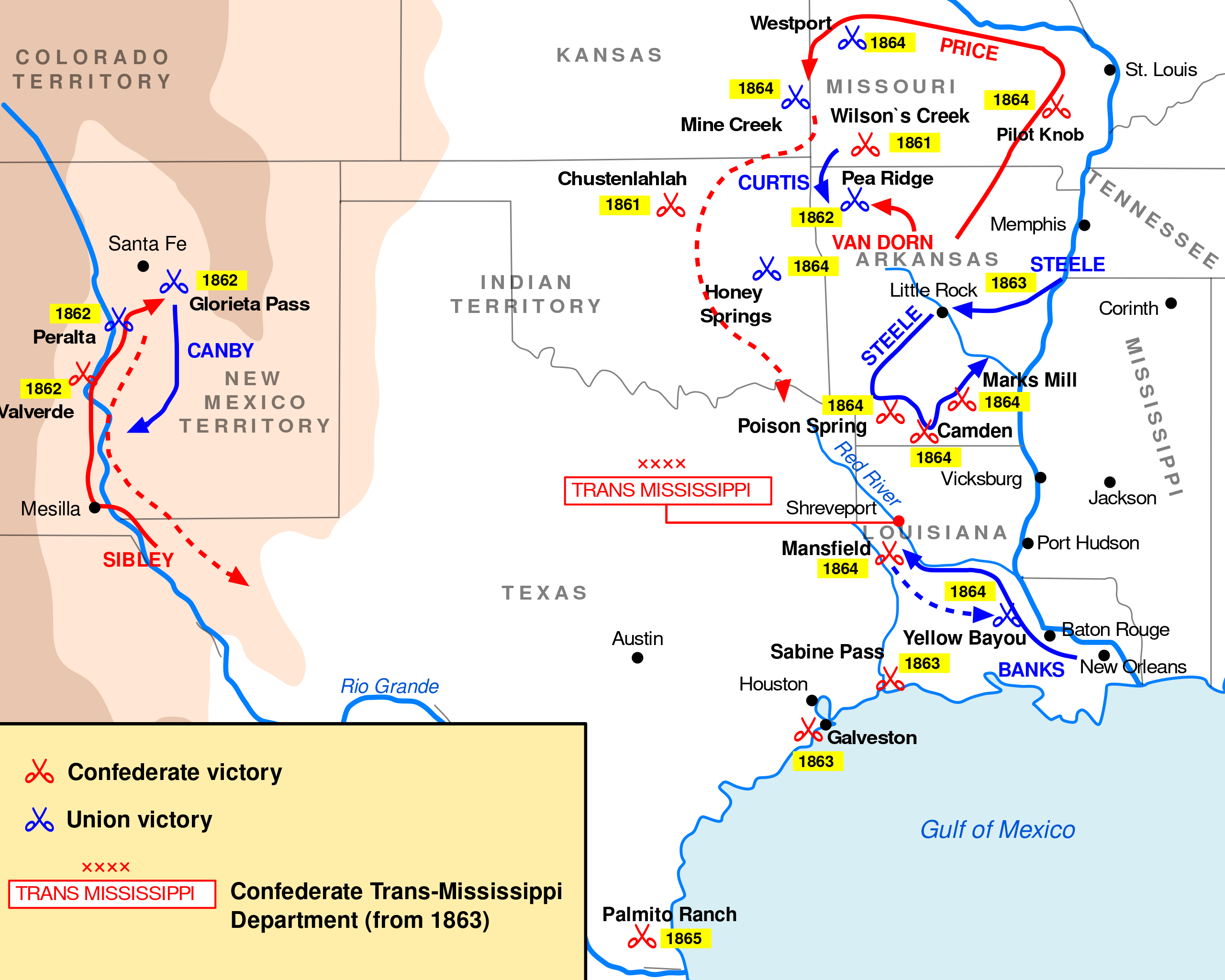
English: Approximate battle locations and routes of major Union and Confederate army campaign operations in the Trans-Mississippi theater between 1861 and 1865, including early movements in the Ozarks, the 1862 New Mexico campaign, 1863 Gulf operations, the 1864 Red River campaign with associated movements in Arkansas, and Price's 1864 campaign in Missouri and eastern Kansas. The map is not drawn to a precise scale, but intends to represent relationships of locations and routes in the area over time.
|
| ⧼wm-license-information-date⧽ | 2008 |
| ⧼wm-license-information-source⧽ | This is a corrected and revised version of the existing File:TRANS-MISSISSIPPI CIVIL WAR.svg |
| ⧼wm-license-information-author⧽ | User:BusterD, revising work by User:Andrein, editing under their previous username, who released this image into the public domain in their original submission statement. |
Using Inkscape software, I've made slight changes in locations and routes on the original file based on critique given in Commons:Deletion requests/Files in Category:Maps of the Trans-Mississippi Theater of the American Civil War. Some copyediting was performed and many labels were adjusted as a consequence of the requested changes.
ترخيص
تاريخ الملف
اضغط على زمن/تاريخ لرؤية الملف كما بدا في هذا الزمن.
| زمن/تاريخ | صورة مصغرة | الأبعاد | مستخدم | تعليق | |
|---|---|---|---|---|---|
| حالي | ★ مراجعة معتمدة 14:57، 15 ديسمبر 2023 | | 1٬500 × 1٬200 (133 كيلوبايت) | Pastakhov (نقاش | مساهمات) | Upload https://upload.wikimedia.org/wikipedia/commons/5/5f/TRANS-MISSISSIPPI_CIVIL_WAR.svg |
لا يمكنك استبدال هذا الملف.
وصلات
لا يوجد صفحات تصل لهذه الصورة.