ملف:Syracuse397.PNG
لا توجد دقة أعلى متوفرة.
Syracuse397.PNG (778 × 599 بكسل حجم الملف: 76 كيلوبايت، نوع MIME: image/png)
وصف قصير
| ⧼wm-license-information-description⧽ |
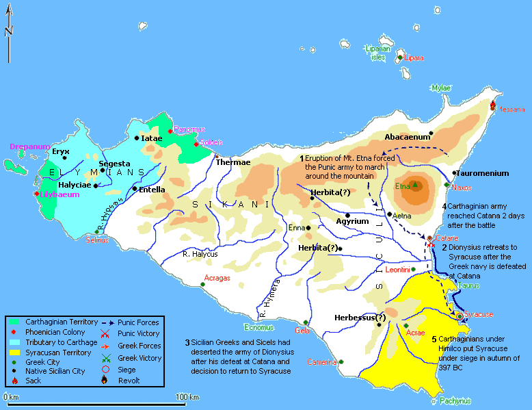
English: This map represents the Punic siege of Syracuse in 397 BC
|
| ⧼wm-license-information-date⧽ | 18:36, 4 September 2009 (UTC) |
| ⧼wm-license-information-source⧽ | قالب:Own work by original uploader This map represents the Punic siege of Syracuse in 397 BC. This represents information from "Sicily: Phoenician, Greek and Roman" by Edward A. Freeman, which is in the Public domain. This file is modified from Map of Sicily designed by Marco Prins-Jona Lendering and was used as per the permission given. |
| ⧼wm-license-information-author⧽ | Maglorbd (talk) |
ترخيص
|

قالب:Original upload log
قالب:Transferred from قالب:Original description page
| زمن/تاريخ | الأبعاد | مستخدم | تعليق |
|---|---|---|---|
| 18:36, 4 September 2009 | 778 × 599 (77,779 bytes) | قالب:Uv | {{Information |Description = |Source = I (~~~) created this work entirely by myself. This map represents the Punic siege of Syracuse in 397 BC. This represents information from "Sicily: Phoenician, Greek and Roman" by Edward A. Freeman, whic |
تاريخ الملف
اضغط على زمن/تاريخ لرؤية الملف كما بدا في هذا الزمن.
| زمن/تاريخ | صورة مصغرة | الأبعاد | مستخدم | تعليق | |
|---|---|---|---|---|---|
| حالي | ★ مراجعة معتمدة 19:10، 15 ديسمبر 2023 | | 778 × 599 (76 كيلوبايت) | Pastakhov (نقاش | مساهمات) | Upload https://upload.wikimedia.org/wikipedia/commons/e/e3/Syracuse397.PNG |
لا يمكنك استبدال هذا الملف.
وصلات
لا يوجد صفحات تصل لهذه الصورة.