ملف:Stobhall Castle and chapel - geograph.org.uk - 82721.jpg
لا توجد دقة أعلى متوفرة.
Stobhall_Castle_and_chapel_-_geograph.org.uk_-_82721.jpg (309 × 205 بكسل حجم الملف: 74 كيلوبايت، نوع MIME: image/jpeg)
وصف قصير
| ⧼wm-license-information-description⧽ |
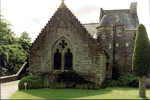
English: Stobhall Castle and chapel. In the middle of the 14th century Sir John Drummond married the last of the Montfichets who owned the lands of Cargill and Stobhall. They moved from about three miles away to Stobhall where the Chapel may already have been standing. Recently the plain plaster ceiling of the passage was taken down and underneath were found the painted beams c. 1578. See http://www.stobhall.com/pages/history.html .
|
| ⧼wm-license-information-date⧽ | 1999 |
| ⧼wm-license-information-source⧽ | From geograph.org.uk |
| ⧼wm-license-information-author⧽ | Andrew Mitchell |
| ⧼wm-license-cc-attribution⧽ (قالب:I18n/Credit line) |
Andrew Mitchell / Stobhall Castle and chapel / |
56°29′32″N 3°24′43″W / 56.4923°N 3.412°W قالب:Object location
_heading:22)
ترخيص
تاريخ الملف
اضغط على زمن/تاريخ لرؤية الملف كما بدا في هذا الزمن.
| زمن/تاريخ | صورة مصغرة | الأبعاد | مستخدم | تعليق | |
|---|---|---|---|---|---|
| حالي | ★ مراجعة معتمدة 07:12، 26 أكتوبر 2023 | | 309 × 205 (74 كيلوبايت) | Pastakhov (نقاش | مساهمات) | Upload https://upload.wikimedia.org/wikipedia/commons/0/04/Stobhall_Castle_and_chapel_-_geograph.org.uk_-_82721.jpg |
لا يمكنك استبدال هذا الملف.
وصلات
لا يوجد صفحات تصل لهذه الصورة.