ملف:Stewart Jamieson 2019 bathymetry Diamantina.jpg
حجم هذه المعاينة: 800 × 460 بكسل. البعدان الآخران: 2٬560 × 1٬471 بكسل | 3٬573 × 2٬053 بكسل.
الملف الأصلي (3٬573 × 2٬053 بكسل حجم الملف: 2٫02 ميجابايت، نوع MIME: image/jpeg)
وصف قصير
| ⧼wm-license-information-description⧽ |
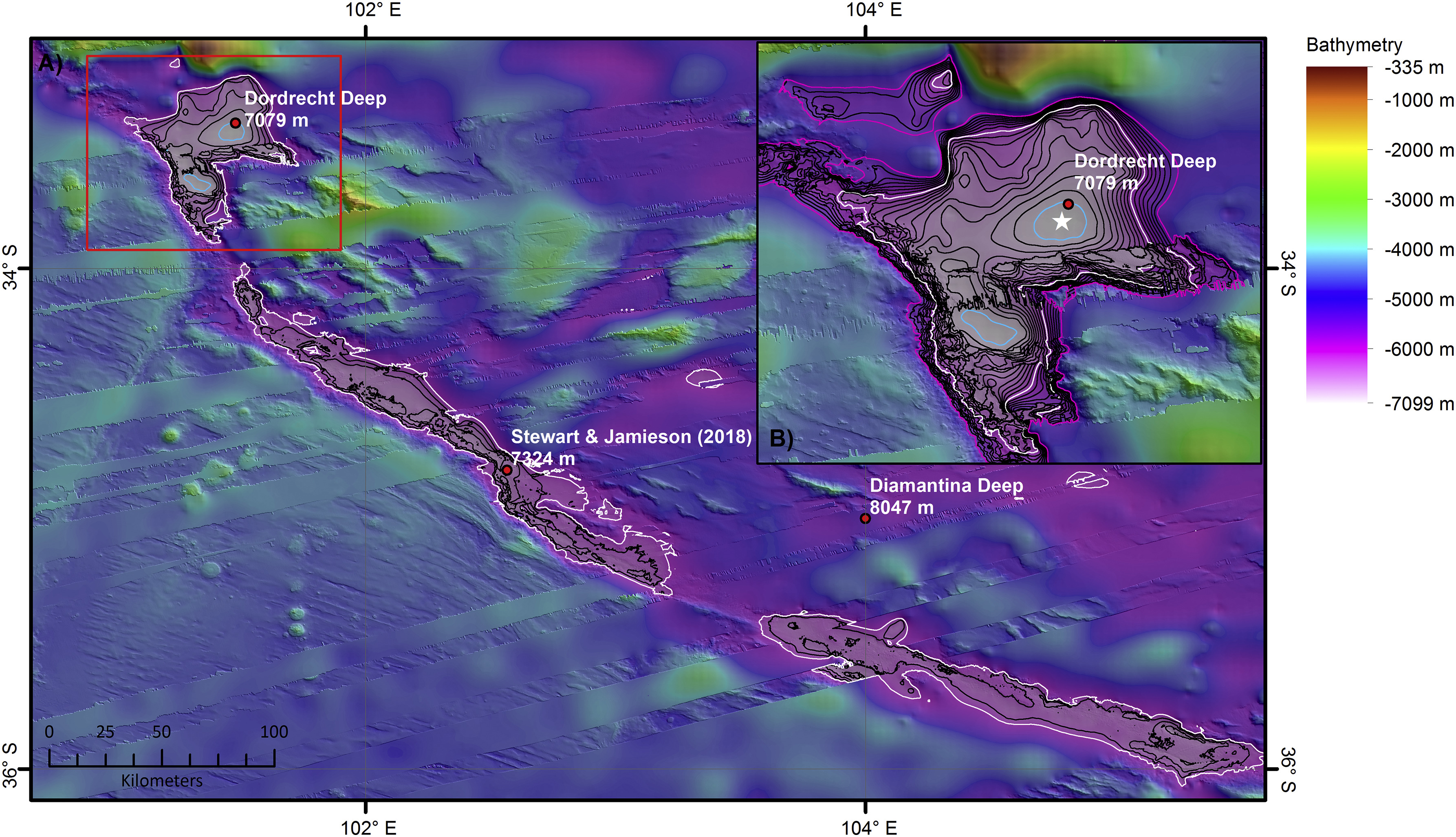
English: Map of the deepest section of the Diamantina Fracture Zone with the locations of published ‘deeps’ (red circles) (Table 1). The 6000 m depth contour is shown in white. The deepest section of the feature is defined by the 7000 m contour (blue). All other contours at 200 m intervals (between 6000 and 7000 m water depth) (B) Inset map of Dordrecht Deep with the deepest point determined during this study (white star = between 7090 and 7100 m water depth) which is within 4 km of the published GEBCO Gazetteer location for Dordrecht Deep. The outer rim of Dordrecht deep lies at 5300 m water depth (pink contour). The 7000 m contour is coloured blue. All other contours at 100 m intervals (between 5300 and 7000 m water depth). For location of inset map see the red box in Fig. 5A. Illumination from 45° at an altitude of 25°.
|
| ⧼wm-license-information-date⧽ | 2019 |
| ⧼wm-license-information-source⧽ | Heather A. Stewart, Alan J. Jamieson: The five deeps: The location and depth of the deepest place in each of the world's oceans. In: Earth-Science Reviews 197, Oktober 2019, 102896, doi:10.1016/j.earscirev.2019.102896. |
| ⧼wm-license-information-author⧽ | Heather A. Stewart, Alan J. Jamieson |
| ⧼wm-license-information-permission⧽ (⧼wm-license-information-permission-reusing-text⧽) |
This is an open access article under the CC BY license (https://creativecommons.org/licenses/BY/4.0/). |
ترخيص
تاريخ الملف
اضغط على زمن/تاريخ لرؤية الملف كما بدا في هذا الزمن.
| زمن/تاريخ | صورة مصغرة | الأبعاد | مستخدم | تعليق | |
|---|---|---|---|---|---|
| حالي | ★ مراجعة معتمدة 17:14، 8 نوفمبر 2023 | | 3٬573 × 2٬053 (2٫02 ميجابايت) | Pastakhov (نقاش | مساهمات) | Upload https://upload.wikimedia.org/wikipedia/commons/0/0c/Stewart_Jamieson_2019_bathymetry_Diamantina.jpg |
لا يمكنك استبدال هذا الملف.
وصلات
لا يوجد صفحات تصل لهذه الصورة.