ملف:St. Xavier High School (Cincinnati), 2000 aerial.jpg

حجم هذه المعاينة: 320 × 600 بكسل.
الملف الأصلي (800 × 1٬500 بكسل حجم الملف: 995 كيلوبايت، نوع MIME: image/jpeg)
وصف قصير
| ⧼wm-license-information-description⧽ |
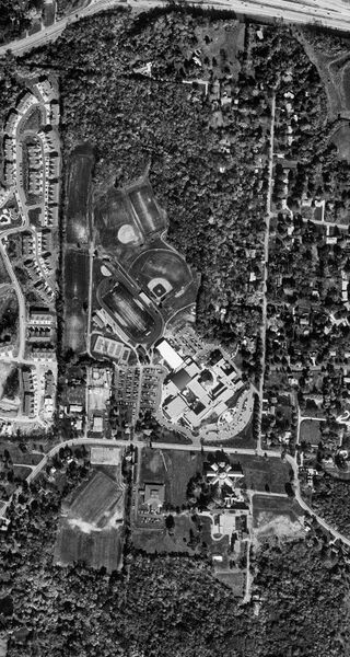
English: Black-and-white digital orthophoto quadrangle (DOQQ) view of St. Xavier High School in Cincinnati, Ohio, taken in 2000. Visible at the top is Ronald Reagan Cross County Highway at the Winton Road exit. The former Girls' Town of America building is shown fronting North Bend Road in the bottom third of the photograph, just a few months before its demolition. This orthophoto includes the 1998 addition of Keating Natatorium, Holy Companions Chapel, and the science wing but predates the Performance Center and rebuilt St. Xavier Stadium. The bottom 800×100 pixels have been cropped, to remove the USGS logo.
|
| ⧼wm-license-information-date⧽ | 2000 |
| ⧼wm-license-information-source⧽ | USGS The National Map, via MSR Maps (formerly TerraServer-USA) |
| ⧼wm-license-information-author⧽ | United States Geological Survey (USGS) |
| ⧼wm-license-information-other-versions⧽ |
39°12′34.2″N 84°30′18″W / 39.209500°N 84.50500°W
,_2000_aerial.jpg¶ms=39_12_34.2_N_84_30_18_W_region:US)
ترخيص
تاريخ الملف
اضغط على زمن/تاريخ لرؤية الملف كما بدا في هذا الزمن.
| زمن/تاريخ | صورة مصغرة | الأبعاد | مستخدم | تعليق | |
|---|---|---|---|---|---|
| حالي | ★ مراجعة معتمدة 06:25، 14 أكتوبر 2023 | | 800 × 1٬500 (995 كيلوبايت) | Pastakhov (نقاش | مساهمات) | Upload https://upload.wikimedia.org/wikipedia/commons/c/c6/St._Xavier_High_School_%28Cincinnati%29%2C_2000_aerial.jpg |
لا يمكنك استبدال هذا الملف.
وصلات
لا يوجد صفحات تصل لهذه الصورة.
,_2000_aerial.jpg&oldid=3112399)