ملف:Sixth Tehran map 1923.jpg

حجم هذه المعاينة: 590 × 599 بكسل. البعد الآخر: 1٬500 × 1٬523 بكسل.
الملف الأصلي (1٬500 × 1٬523 بكسل حجم الملف: 653 كيلوبايت، نوع MIME: image/jpeg)
وصف قصير
| ⧼wm-license-information-description⧽ |
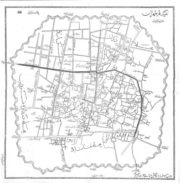
English: Sixth Tehran map
|
| ⧼wm-license-information-date⧽ | 1923 |
| ⧼wm-license-information-source⧽ | http://shahrefarang.com/maps-tehran-qajar/ |
| ⧼wm-license-information-author⧽ | science ministry of Iran |
ترخيص
تاريخ الملف
اضغط على زمن/تاريخ لرؤية الملف كما بدا في هذا الزمن.
| زمن/تاريخ | صورة مصغرة | الأبعاد | مستخدم | تعليق | |
|---|---|---|---|---|---|
| حالي | ★ مراجعة معتمدة 21:05، 17 ديسمبر 2023 | | 1٬500 × 1٬523 (653 كيلوبايت) | Pastakhov (نقاش | مساهمات) | Upload https://upload.wikimedia.org/wikipedia/commons/b/bb/Sixth_Tehran_map_1923.jpg |
لا يمكنك استبدال هذا الملف.
وصلات
لا يوجد صفحات تصل لهذه الصورة.
تصنيفات:
- 1923 maps of Iran
- 1923 in Tehran
- Maps of Tehran
- City gates of Tehran
- Bagh-e Shah Gate
- Doshan Tappeh Gate
- Dowlat Gate (Naser Wall)
- Dulab Gate (Naser Wall)
- Ghar Gate
- Gomrok Gate
- Khaniabad Gate
- Khorasan Gate (Tehran)
- Qazvin Gate (Naser Wall)
- Rah Ahan Gate
- Shah Abdol-Azim Gate (Naser Wall)
- Shemiran Gate (Naser Wall)
- Yusef Abad Gate
- Naser Wall
- Tehran–Ray Railway