ملف:Ship and Eight Bells pub (site of) St Marychurch Street, Rotherhithe, London, SE16 - geograph.org.uk - 1600836.jpg
لا توجد دقة أعلى متوفرة.
Ship_and_Eight_Bells_pub_(site_of)_St_Marychurch_Street,_Rotherhithe,_London,_SE16_-_geograph.org.uk_-_1600836.jpg (640 × 480 بكسل حجم الملف: 108 كيلوبايت، نوع MIME: image/jpeg)
وصف قصير
| ⧼wm-license-information-description⧽ |
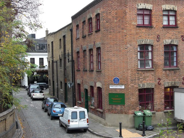
English: Ship & Eight Bells pub (site of) St Marychurch Street, Rotherhithe, London, SE16 This was first recorded in 1757 and finished trading in 1819. Grices Granary or Wharf was built on the site that still remains today with an address of number 82. In 1976 Sands Films obtained the building. As may be seen, the 'Mayflower' pub is within spitting distance and on the left is St Marys Church. Possible point of interest re the two metal bollards :- in the 1960's / 1970's there were a great number of such bollards around the immediate vicinity, practically all were cannons from ships that had been dismantled in the area - many were stolen for either their 'historic' of 'scrap' value.
|
| ⧼wm-license-information-date⧽ | 2009 |
| ⧼wm-license-information-source⧽ | From geograph.org.uk |
| ⧼wm-license-information-author⧽ | Chris Lordan |
| ⧼wm-license-cc-attribution⧽ (قالب:I18n/Credit line) |
Chris Lordan / Ship & Eight Bells pub (site of) St Marychurch Street, Rotherhithe, London, SE16 / |
51°30′03″N 0°03′04″W / 51.50080°N 0.0510°W قالب:Object location
_St_Marychurch_Street,_Rotherhithe,_London,_SE16_-_geograph.org.uk_-_1600836.jpg¶ms=51.5008_N_0.051_W_source:geograph-osgb36(TQ35377978)_heading:315)
ترخيص
تاريخ الملف
اضغط على زمن/تاريخ لرؤية الملف كما بدا في هذا الزمن.
| زمن/تاريخ | صورة مصغرة | الأبعاد | مستخدم | تعليق | |
|---|---|---|---|---|---|
| حالي | ★ مراجعة معتمدة 20:57، 30 نوفمبر 2023 | | 640 × 480 (108 كيلوبايت) | Pastakhov (نقاش | مساهمات) | Upload https://upload.wikimedia.org/wikipedia/commons/6/65/Ship_and_Eight_Bells_pub_%28site_of%29_St_Marychurch_Street%2C_Rotherhithe%2C_London%2C_SE16_-_geograph.org.uk_-_1600836.jpg |
لا يمكنك استبدال هذا الملف.
وصلات
لا يوجد صفحات تصل لهذه الصورة.
_St_Marychurch_Street,_Rotherhithe,_London,_SE16_-_geograph.org.uk_-_1600836.jpg&oldid=3640045)