ملف:SaylorvilleMines.png
لا توجد دقة أعلى متوفرة.
SaylorvilleMines.png (586 × 530 بكسل حجم الملف: 65 كيلوبايت، نوع MIME: image/png)
وصف قصير
| ⧼wm-license-information-description⧽ |
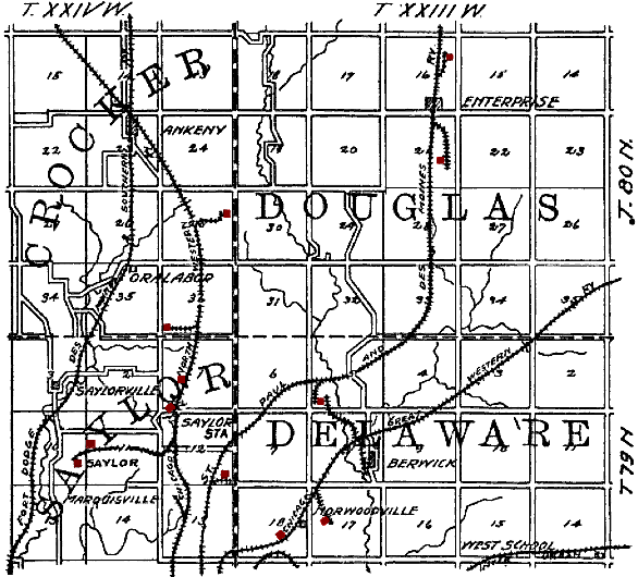
English: Original caption: "Figure 35. Map showing location of principal Polk County mines outside of the Des Moines district." en:Saylorville, Iowa is in the lower left quadrant. Mines have been tinted red by the uploader. The railroads shown on the map are: en:Fort Dodge, Des Moines and Southern Railroad, en:Chicago and North Western Railroad, en:St. Paul and Des Moines Railroad, en:Chicago Great Western Railroad and an unidentified en:Interurban.
|
| ⧼wm-license-information-date⧽ | 1909 |
| ⧼wm-license-information-source⧽ | The Coal Deposits of Iowa, Chapter I of Iowa Geological Survey Annual Report, 1908 |
| ⧼wm-license-information-author⧽ | Henry Hinds |
41°41′43.71″N 93°33′40.63″W / 41.6954750°N 93.5612861°W
ترخيص
تاريخ الملف
اضغط على زمن/تاريخ لرؤية الملف كما بدا في هذا الزمن.
| زمن/تاريخ | صورة مصغرة | الأبعاد | مستخدم | تعليق | |
|---|---|---|---|---|---|
| حالي | ★ مراجعة معتمدة 19:06، 7 أكتوبر 2023 | | 586 × 530 (65 كيلوبايت) | Pastakhov (نقاش | مساهمات) | Upload https://upload.wikimedia.org/wikipedia/commons/2/21/SaylorvilleMines.png |
لا يمكنك استبدال هذا الملف.
وصلات
لا يوجد صفحات تصل لهذه الصورة.