ملف:Saint-Pierre and Miquelon EEZ map-en.svg

حجم معاينة PNG لذلك الملف ذي الامتداد SVG: 562 × 599 بكسل. البعد الآخر: 1٬920 × 2٬048 بكسل.
الملف الأصلي (ملف SVG، أبعاده 750 × 800 بكسل، حجم الملف: 315 كيلوبايت)
وصف قصير
قالب:Igen
| ⧼wm-license-information-description⧽ |
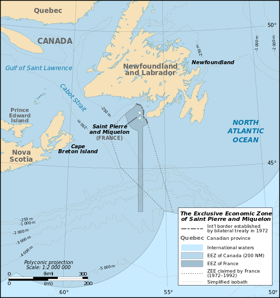
English: Map of the Exclusive Economic Zone of the French oversea collectivity of Saint Pierre and Miquelon off the south coast of Newfoundland, Canada, with simplified bathymetric contours.
|
| ⧼wm-license-information-date⧽ | 2009 |
| ⧼wm-license-information-source⧽ | English translation of قالب:F |
| ⧼wm-license-information-author⧽ | Eric Gaba (Sting - قالب:Wf)
English translation by D. V. Wiebe |
| ⧼wm-license-information-permission⧽ (⧼wm-license-information-permission-reusing-text⧽) |
|
| ⧼wm-license-information-other-versions⧽ |
ترخيص
|

تاريخ الملف
اضغط على زمن/تاريخ لرؤية الملف كما بدا في هذا الزمن.
| زمن/تاريخ | صورة مصغرة | الأبعاد | مستخدم | تعليق | |
|---|---|---|---|---|---|
| حالي | ★ مراجعة معتمدة 19:16، 10 أكتوبر 2023 | | 750 × 800 (315 كيلوبايت) | Pastakhov (نقاش | مساهمات) | Upload https://upload.wikimedia.org/wikipedia/commons/7/79/Saint-Pierre_and_Miquelon_EEZ_map-en.svg |
لا يمكنك استبدال هذا الملف.
وصلات
لا يوجد صفحات تصل لهذه الصورة.
معلومات الصورة (ميتا)
تصنيفات:
- Self-published work
- 2009 maps
- Bathymetric maps of the North Atlantic
- Canada-France border
- Maps of Newfoundland
- Maps with polyconic projection
- English-language SVG maps
- SVG maps of Newfoundland and Labrador
- SVG maps of Saint-Pierre and Miquelon
- Maps of territorial waters of Canada
- Maps of territorial waters of France