ملف:RothenburgObDerTauberAltstadt2022OSM.png

حجم هذه المعاينة: 638 × 599 بكسل. البعدان الآخران: 2٬180 × 2٬048 بكسل | 3٬629 × 3٬410 بكسل.
الملف الأصلي (3٬629 × 3٬410 بكسل حجم الملف: 5٫55 ميجابايت، نوع MIME: image/png)
وصف قصير
| ⧼wm-license-information-description⧽ |
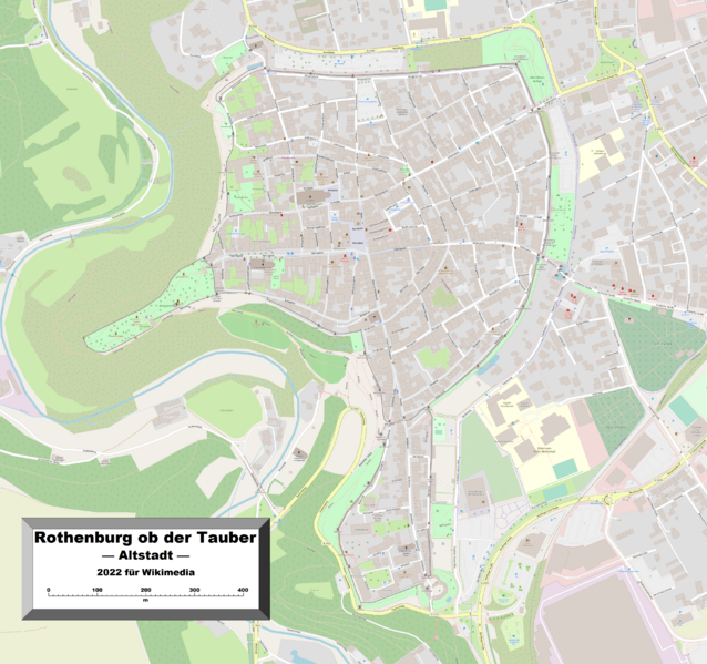
English: This map of Rothenburg ob der Tauber's old town shows the town's geographical details, and is likely the most comprehensive map of the old town in this respect that you'll find anywhere online. It has been stitched together from panels of Open Street Map (which is freely licensed to all) with some details, namely those of a commercial nature, deleted, by the uploader.
|
| ⧼wm-license-information-date⧽ | 2022 |
| ⧼wm-license-information-source⧽ | ⧼Wm-license-own-work⧽ |
| ⧼wm-license-information-author⧽ | Kelisi |
| ⧼wm-license-information-permission⧽ (⧼wm-license-information-permission-reusing-text⧽) |
The aforesaid website is freely usable to all. |
ترخيص
|
تاريخ الملف
اضغط على زمن/تاريخ لرؤية الملف كما بدا في هذا الزمن.
| زمن/تاريخ | صورة مصغرة | الأبعاد | مستخدم | تعليق | |
|---|---|---|---|---|---|
| حالي | ★ مراجعة معتمدة 18:39، 18 أكتوبر 2023 | | 3٬629 × 3٬410 (5٫55 ميجابايت) | Pastakhov (نقاش | مساهمات) | Upload https://upload.wikimedia.org/wikipedia/commons/1/16/RothenburgObDerTauberAltstadt2022OSM.png |
لا يمكنك استبدال هذا الملف.
وصلات
لا يوجد صفحات تصل لهذه الصورة.