ملف:Regional Internet Registries world map.svg

حجم معاينة PNG لذلك الملف ذي الامتداد SVG: 800 × 353 بكسل. البعد الآخر: 2٬560 × 1٬130 بكسل.
الملف الأصلي (ملف SVG، أبعاده 940 × 415 بكسل، حجم الملف: 1٫48 ميجابايت)
وصف قصير
| ⧼wm-license-information-description⧽ |
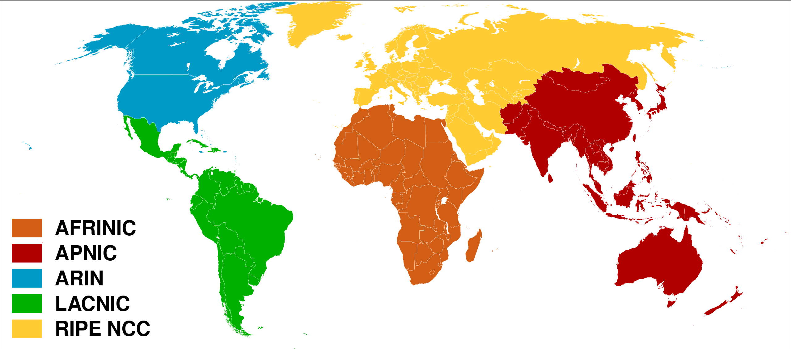
العربية: خريطة العالم بحسب سجلات الإنترنت الإقليمية.
English: Regional Internet Registries world map.
Español: Mapa de Registros Regionales de Internet.
Français : Carte du monde des organisations de registre Internet régional.
|
| ⧼wm-license-information-date⧽ | 2009-01-28 12:01 (UTC) |
| ⧼wm-license-information-source⧽ | |
| ⧼wm-license-information-author⧽ | |
| ⧼wm-license-information-other-versions⧽ |
ملف:Regional Internet Registries world map-ar.svg Arabic (العربيّة) |
ترخيص
|
|
هذا الملفُّ مُرخَّص بموجب رخصة المشاع الإبداعي نسبة المُصنَّف إِلى مؤلفه - المشاركة بالمثل 3.0 العامة. |
قالب:Original upload log
This image is a derivative work of the following images:
- File:Rir.gif licensed with Cc-by-sa-2.5, Cc-by-sa-2.5/en
- 2006-04-02T01:24:59Z Dork 300x163 (3093 Bytes) Regional Internet Registries (containing AFRINIC)
- File:BlankMap-World6,_compact.svg licensed with PD-self, PD-self/en
- 2008-12-02T18:21:18Z Lokal Profil 940x415 (1518276 Bytes) Reverted to version as of 14:51, 13 June 2008, new image has non of the complexity (i.e. colouring abilities etc.) of the old
- 2008-12-02T17:29:39Z Harbin 1326x601 (176022 Bytes)
- 2008-12-02T17:26:08Z Harbin 1425x625 (189017 Bytes)
- 2008-06-13T14:51:25Z Lokal Profil 940x415 (1518276 Bytes) Syncing with [[:Image:BlankMap-World6.svg]] version (01:30, March 29, 2008). Sadly enough the validator does not seem to like rdf element of the metadata although it should work acording to http://www.w3schools.com/rdf/rdf_ma
- 2008-02-08T20:55:35Z CarolSpears 940x415 (1528750 Bytes) validated, maybe
- 2007-12-14T19:51:17Z Lokal Profil 940x415 (1529675 Bytes) Readded an ocean object but this one is square instead of the original elliptic one
- 2007-12-14T19:19:56Z Lokal Profil 940x415 (1529845 Bytes) {{Information |Description=Detailed SVG map with grouping enabled to connect all non-contiguous parts of a country's territory for easy colouring. Smaller countries can also be represented by larger circles to show their data
تاريخ الملف
اضغط على زمن/تاريخ لرؤية الملف كما بدا في هذا الزمن.
| زمن/تاريخ | صورة مصغرة | الأبعاد | مستخدم | تعليق | |
|---|---|---|---|---|---|
| حالي | ★ مراجعة معتمدة 00:11، 27 نوفمبر 2023 | | 940 × 415 (1٫48 ميجابايت) | Pastakhov (نقاش | مساهمات) | Upload https://upload.wikimedia.org/wikipedia/commons/9/95/Regional_Internet_Registries_world_map.svg |
لا يمكنك استبدال هذا الملف.
وصلات
لا يوجد صفحات تصل لهذه الصورة.