ملف:Queen Charlotte Islands Map.png

حجم هذه المعاينة: 392 × 600 بكسل. البعد الآخر: 496 × 759 بكسل.
الملف الأصلي (496 × 759 بكسل حجم الملف: 23 كيلوبايت، نوع MIME: image/png)
وصف قصير
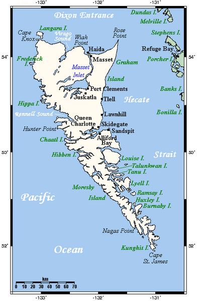
A map showing Haida Gwaii's main towns and other physical features. This map's source is here, with the uploader's modifications, and the GMT homepage Archive copy at the Internet Archive says that the tools are released under the GNU General Public License.
Uploaded from en:Image:HaidaGwaiiOMC.png by TCY
ترخيص
تاريخ الملف
اضغط على زمن/تاريخ لرؤية الملف كما بدا في هذا الزمن.
| زمن/تاريخ | صورة مصغرة | الأبعاد | مستخدم | تعليق | |
|---|---|---|---|---|---|
| حالي | ★ مراجعة معتمدة 12:47، 27 أكتوبر 2023 | | 496 × 759 (23 كيلوبايت) | Pastakhov (نقاش | مساهمات) | Upload https://upload.wikimedia.org/wikipedia/commons/c/c1/Queen_Charlotte_Islands_Map.png |
لا يمكنك استبدال هذا الملف.
وصلات
لا يوجد صفحات تصل لهذه الصورة.