ملف:Port Allen Lock Louisiana aerial view.jpg

حجم هذه المعاينة: 480 × 600 بكسل. البعد الآخر: 1٬201 × 1٬500 بكسل.
الملف الأصلي (1٬201 × 1٬500 بكسل حجم الملف: 771 كيلوبايت، نوع MIME: image/jpeg)
| ⧼wm-license-information-description⧽ |
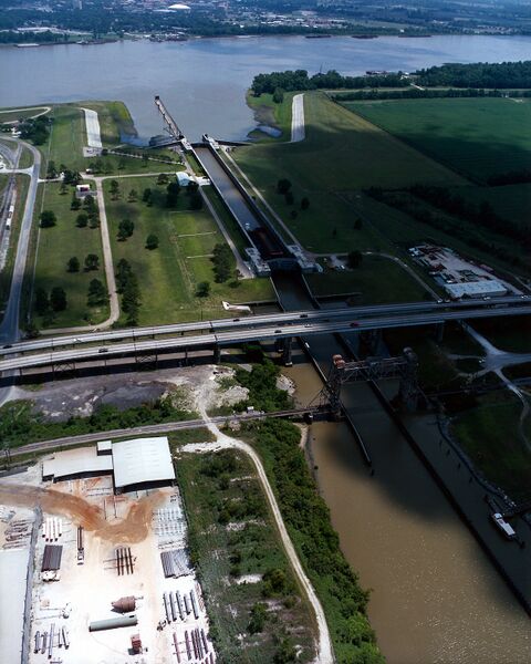
English: The Port Allen Lock at Port Allen, Louisiana, USA. Port Allen lies across the Mississippi River on the west side opposite Baton Rouge. The Port Allen Lock is a gateway to the Gulf Intracoastal Waterway. View is to the east across the Mississippi. Louisiana State Route 1 crosses the canal next to the lock.
|
| ⧼wm-license-information-date⧽ | 1999 |
| ⧼wm-license-information-source⧽ | U.S. Army Corps of Engineers Digital Visual Library Image page Image description page Digital Visual Library home page |
| ⧼wm-license-information-author⧽ | Michael Maples, U.S. Army Corps of Engineers |
| ⧼wm-license-information-permission⧽ (⧼wm-license-information-permission-reusing-text⧽) |
|
| قالب:Location/i18n | Port Allen, Louisiana, USA |
تاريخ الملف
اضغط على زمن/تاريخ لرؤية الملف كما بدا في هذا الزمن.
| زمن/تاريخ | صورة مصغرة | الأبعاد | مستخدم | تعليق | |
|---|---|---|---|---|---|
| حالي | ★ مراجعة معتمدة 10:20، 10 نوفمبر 2023 | | 1٬201 × 1٬500 (771 كيلوبايت) | Pastakhov (نقاش | مساهمات) | Upload https://upload.wikimedia.org/wikipedia/commons/7/72/Port_Allen_Lock_Louisiana_aerial_view.jpg |
لا يمكنك استبدال هذا الملف.
وصلات
لا يوجد صفحات تصل لهذه الصورة.