ملف:Poison Spring Battlefield Arkansas.jpg

الملف الأصلي (810 × 1٬060 بكسل حجم الملف: 479 كيلوبايت، نوع MIME: image/jpeg)
وصف قصير
| ⧼wm-license-information-description⧽ |
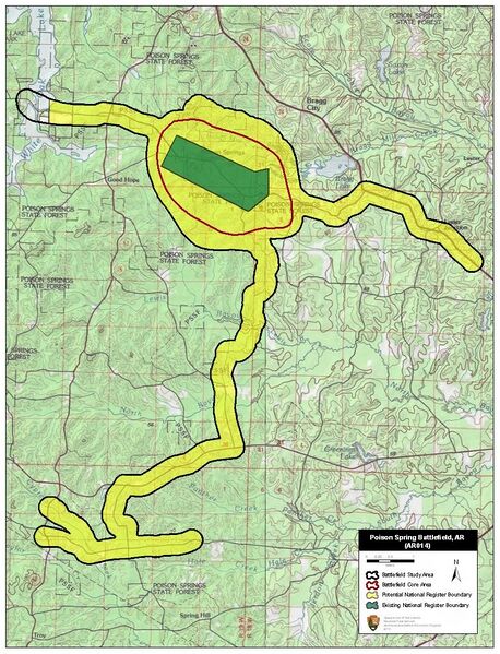
English: Map of battlefield core and study areas.
The 1993 Study Area boundary was a generic polygon that did not accurately reflect the size and character of the battlefield landscape. The ABPP significantly reduced the Study Area to more accurately reflect troop movements, areas of fighting, and historic road alignments. The Study Area was revised to include the location of camps from which the Confederates marched north to intercept the Federal wagon train; the route to Poison Spring; and the location where Federal reinforcements met Williams’ troops near White Oak Creek and began moving east. The eastern arm of the Study Area represents the route taken by the portion of Williams’ force that was able to retreat in order toward Union-occupied Camden. The Core Area was reduced slightly to better reflect actual troop movements and areas of fighting. |
| ⧼wm-license-information-date⧽ | 2011 |
| ⧼wm-license-information-source⧽ | National Park Service |
| ⧼wm-license-information-author⧽ | American Battlefield Protection Program |
ترخيص
تاريخ الملف
اضغط على زمن/تاريخ لرؤية الملف كما بدا في هذا الزمن.
| زمن/تاريخ | صورة مصغرة | الأبعاد | مستخدم | تعليق | |
|---|---|---|---|---|---|
| حالي | ★ مراجعة معتمدة 09:48، 16 يناير 2024 | | 810 × 1٬060 (479 كيلوبايت) | Pastakhov (نقاش | مساهمات) | Upload https://upload.wikimedia.org/wikipedia/commons/3/39/Poison_Spring_Battlefield_Arkansas.jpg |
لا يمكنك استبدال هذا الملف.
وصلات
لا يوجد صفحات تصل لهذه الصورة.