ملف:Piloto Pardo Islands Map.png

حجم هذه المعاينة: 800 × 467 بكسل. البعد الآخر: 1٬164 × 680 بكسل.
الملف الأصلي (1٬164 × 680 بكسل حجم الملف: 264 كيلوبايت، نوع MIME: image/png)
وصف قصير
| ⧼wm-license-information-description⧽ |
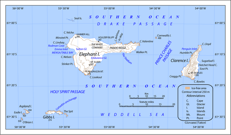
English: Piloto Pardo Islands Map. Conic A projection. Standard parallel -61.25
ATTENTION: In British Antarctic maps (not in Argentina and Chile), “Prince Charles Passage” is called Prince Charles Strait and is between Elephant Island and Cornwallis Island and NOT between Elephant Island and Clarence Island! See also: → Map 13676: South Shetland Islands by UK Antarctic Place-names Committee. |
| ⧼wm-license-information-date⧽ | 2011 |
| ⧼wm-license-information-source⧽ | ⧼Wm-license-own-work⧽ |
| ⧼wm-license-information-author⧽ | Gi |
| ⧼wm-license-information-other-versions⧽ |
ترخيص
|
تاريخ الملف
اضغط على زمن/تاريخ لرؤية الملف كما بدا في هذا الزمن.
| زمن/تاريخ | صورة مصغرة | الأبعاد | مستخدم | تعليق | |
|---|---|---|---|---|---|
| حالي | ★ مراجعة معتمدة 14:34، 7 ديسمبر 2023 | | 1٬164 × 680 (264 كيلوبايت) | Pastakhov (نقاش | مساهمات) | Upload https://upload.wikimedia.org/wikipedia/commons/4/4a/Piloto_Pardo_Islands_Map.png |
لا يمكنك استبدال هذا الملف.
وصلات
لا يوجد صفحات تصل لهذه الصورة.