ملف:Ph locator map Olango.png
لا توجد دقة أعلى متوفرة.
Ph_locator_map_Olango.png (300 × 350 بكسل حجم الملف: 70 كيلوبايت، نوع MIME: image/png)
وصف قصير
| ⧼wm-license-information-description⧽ |
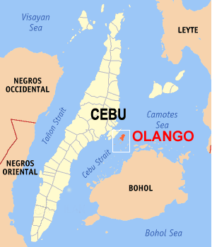
English: Map of Cebu with Olango Island highlighted
|
| ⧼wm-license-information-date⧽ | قالب:Original upload date (قالب:Original text) |
| ⧼wm-license-information-source⧽ | ⧼Wm-license-own-work⧽ (قالب:Original text) |
| ⧼wm-license-information-author⧽ | Drakesketchit (talk) |
ترخيص
|

قالب:Original upload log
قالب:Original description page
- 2008-07-13 13:39 Drakesketchit 300×350× (71552 bytes) {{Information |Description=Map of Cebu with Olango Island highlighted |Source=I created this work entirely by myself. |Date=13 July 2007 |Author=~~~ |other_versions= }}
تاريخ الملف
اضغط على زمن/تاريخ لرؤية الملف كما بدا في هذا الزمن.
| زمن/تاريخ | صورة مصغرة | الأبعاد | مستخدم | تعليق | |
|---|---|---|---|---|---|
| حالي | ★ مراجعة معتمدة 03:05، 3 ديسمبر 2023 | | 300 × 350 (70 كيلوبايت) | Pastakhov (نقاش | مساهمات) | Upload https://upload.wikimedia.org/wikipedia/commons/1/16/Ph_locator_map_Olango.png |
لا يمكنك استبدال هذا الملف.
وصلات
لا يوجد صفحات تصل لهذه الصورة.