ملف:Pennsylvania canals.png
لا توجد دقة أعلى متوفرة.
Pennsylvania_canals.png (759 × 414 بكسل حجم الملف: 133 كيلوبايت، نوع MIME: image/png)
وصف قصير
| ⧼wm-license-information-description⧽ |
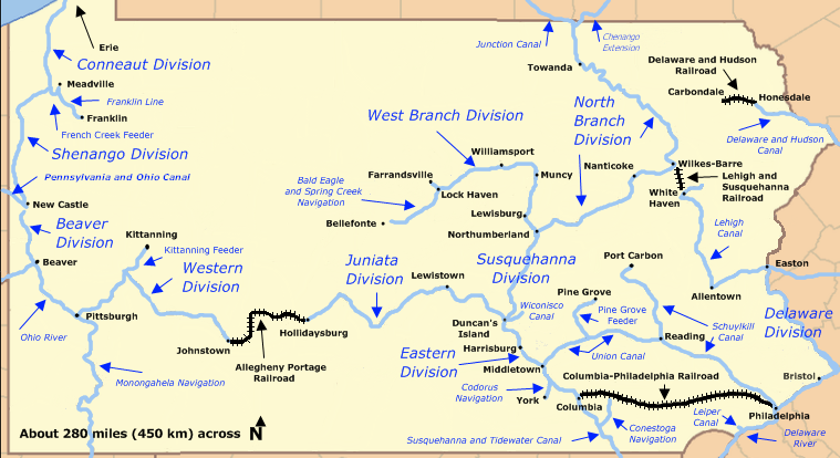
English: Historic canals of Pennsylvania, including divisions of the 19th-century Pennsylvania Canal system plus navigable rivers, other canals, and four railroads that made the system more useful. Not all of the canals shown on the map existed at the same time.
|
| ⧼wm-license-information-date⧽ | 2009 |
| ⧼wm-license-information-source⧽ | Based on File:Pennsylvania Locator Map.PNG which is a modification by User:Ruhrfisch of a map from the U.S. Census site here and further modified by User:Finetooth with reference to a map by William H. Shank in The Amazing Pennsylvania Canals, 150th Anniversary Edition, published by the American Canal and Transportation Center in 1986 at York, Pennsylvania, ISBN 0-933788-37-1, and a Pennsylvania Canal Society map here. |
| ⧼wm-license-information-author⧽ | Finetooth, Ruhrfisch, U.S. Census |
ترخيص
|

تاريخ الملف
اضغط على زمن/تاريخ لرؤية الملف كما بدا في هذا الزمن.
| زمن/تاريخ | صورة مصغرة | الأبعاد | مستخدم | تعليق | |
|---|---|---|---|---|---|
| حالي | ★ مراجعة معتمدة 20:07، 19 أكتوبر 2023 | | 759 × 414 (133 كيلوبايت) | Pastakhov (نقاش | مساهمات) | Upload https://upload.wikimedia.org/wikipedia/commons/b/bb/Pennsylvania_canals.png |
لا يمكنك استبدال هذا الملف.
وصلات
لا يوجد صفحات تصل لهذه الصورة.
معلومات الصورة (ميتا)
تصنيفات:
- Self-published work
- Maps of Pennsylvania
- Canals in Pennsylvania
- Lehigh Canal
- Allegheny Portage Railroad
- Delaware and Hudson Canal
- Schuylkill Canal
- Pennsylvania Canal
- Pennsylvania Canal (Delaware Division)
- Pennsylvania Canal (North Branch Division)
- Pennsylvania Canal (West Branch Division)
- Philadelphia and Columbia Railroad
- Union Canal (Pennsylvania)
- Maps of canals in the United States