ملف:Parishes in Guernsey (St Pierre du Bois shaded).gif
لا توجد دقة أعلى متوفرة.
Parishes_in_Guernsey_(St_Pierre_du_Bois_shaded).gif (385 × 315 بكسل حجم الملف: 5 كيلوبايت، نوع MIME: image/gif)
وصف قصير
| ⧼wm-license-information-description⧽ |
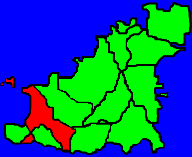
English: This map shows the location of St. Pierre Du Bois (shaded red) in relation to the rest of Guernsey. The surrounding parishes are St. Saviours, Torteval and Forest.
|
| ⧼wm-license-information-date⧽ | 2006 |
| ⧼wm-license-information-source⧽ | قالب:Transferred from |
| ⧼wm-license-information-author⧽ | قالب:Uap, Tra at en.wikipedia. |
ترخيص
| [ This image has been (or is hereby) released into the public domain by its author, Sgfoote at the wikipedia project. This applies worldwide. In case this is not legally possible: Deutsch · Ελληνικά · English · Plattdüütsch · 中文(简体) · 中文(繁體) · +/− |
قالب:Original upload log
| زمن/تاريخ | الأبعاد | مستخدم | تعليق |
|---|---|---|---|
| 2006-09-17 01:52 | 385×315× (5196 bytes) | Tra | Clearer version of image (created by myself) |
| 2006-03-25 23:02 | 385×315× (37049 bytes) | Sgfoote | == Summary == This map shows the position of [[St Peter's, Guernsey|St Pierre du Bois]] in relation to the rest of [[Guernsey]]. I created this myself based on [[Image:Parishes in Guernsey (The Forest shaded).GIF]] {{PD-self}} [[Category:Parishes in Gue |
تاريخ الملف
اضغط على زمن/تاريخ لرؤية الملف كما بدا في هذا الزمن.
| زمن/تاريخ | صورة مصغرة | الأبعاد | مستخدم | تعليق | |
|---|---|---|---|---|---|
| حالي | ★ مراجعة معتمدة 19:04، 30 أكتوبر 2023 | | 385 × 315 (5 كيلوبايت) | Pastakhov (نقاش | مساهمات) | Upload https://upload.wikimedia.org/wikipedia/commons/8/86/Parishes_in_Guernsey_%28St_Pierre_du_Bois_shaded%29.gif |
لا يمكنك استبدال هذا الملف.
وصلات
لا يوجد صفحات تصل لهذه الصورة.
.gif&oldid=3306512)