ملف:Paraná River Floodplain.jpg
لا توجد دقة أعلى متوفرة.
Paraná_River_Floodplain.jpg (720 × 480 بكسل حجم الملف: 179 كيلوبايت، نوع MIME: image/jpeg)
| ⧼wm-license-information-description⧽ |
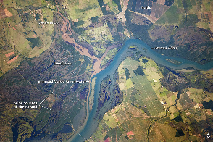
English: Paraná River Floodplain, Brazil
The Paraná River appears as a wide, blue strip with the muddy brown water of the smaller Verde River entering from the northwest (top left). An extensive wetland (dark green) occupies most of the left half of this astronaut photograph, and the floodplain reaches a width of 11 kilometers (about 7 miles). The thin line of a road crossing the floodplain also gives a sense of scale. Above the Paraná-Verde confluence (image center), the floodplain is much narrower.
|
||
| ⧼wm-license-information-date⧽ | acquired on February 5, 2012 | ||
| ⧼wm-license-information-source⧽ | http://earthobservatory.nasa.gov/IOTD/view.php?id=77444&src=eoa-iotd | ||
| ⧼wm-license-information-author⧽ | NASA Astronaut photograph ISS030-E-90012 | ||
| ⧼wm-license-information-permission⧽ (⧼wm-license-information-permission-reusing-text⧽) |
|
||
| ⧼wm-license-information-other-versions⧽ |
See [1] for a larger version |
![[1]](http://eoimages.gsfc.nasa.gov/images/imagerecords/77000/77444/ISS030-E-090012_lrg.jpg)
تاريخ الملف
اضغط على زمن/تاريخ لرؤية الملف كما بدا في هذا الزمن.
| زمن/تاريخ | صورة مصغرة | الأبعاد | مستخدم | تعليق | |
|---|---|---|---|---|---|
| حالي | ★ مراجعة معتمدة 17:48، 1 ديسمبر 2023 | | 720 × 480 (179 كيلوبايت) | Pastakhov (نقاش | مساهمات) | Upload https://upload.wikimedia.org/wikipedia/commons/e/e0/Paran%C3%A1_River_Floodplain.jpg |
لا يمكنك استبدال هذا الملف.
وصلات
لا يوجد صفحات تصل لهذه الصورة.