ملف:Nordaustlandet labelled.png
لا توجد دقة أعلى متوفرة.
Nordaustlandet_labelled.png (524 × 528 بكسل حجم الملف: 119 كيلوبايت، نوع MIME: image/png)
وصف قصير
| ⧼wm-license-information-description⧽ |
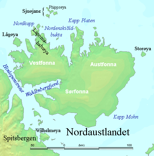
English: Map detailing the marine features of Spitsbergen in the Svalbard archipelago. Settlements and mountains are indicated and labelled. See also Image:Spitsbergen mountains and marine features labelled.png. Locations were labelled mainly based on detailed maps from svalbard-images.com (sample of south Spitsbergen linked), cross-referenced with other map sources where possible. Norwegian Polar Institute figures were used for mountain names and heights, which are given in meters above sea level.
|
| ⧼wm-license-information-date⧽ | قالب:Original upload date |
| ⧼wm-license-information-source⧽ | No machine-readable source provided. Own work assumed (based on copyright claims). |
| ⧼wm-license-information-author⧽ | No machine-readable author provided. TheGrappler assumed (based on copyright claims). |
ترخيص
DEMIS World Map Server Archive copy at the Internet Archive generated this map from Public Domain sources. DEMIS does not claim any rights over the resultant image ([1] Archive copy at the Internet Archive). Alterations, including the addition of settlements and captions, were performed on 24 July 2006 by User:TheGrappler, the uploader, who releases all associated rights.
derivative works
تاريخ الملف
اضغط على زمن/تاريخ لرؤية الملف كما بدا في هذا الزمن.
| زمن/تاريخ | صورة مصغرة | الأبعاد | مستخدم | تعليق | |
|---|---|---|---|---|---|
| حالي | ★ مراجعة معتمدة 20:11، 10 أكتوبر 2023 | | 524 × 528 (119 كيلوبايت) | Pastakhov (نقاش | مساهمات) | Upload https://upload.wikimedia.org/wikipedia/commons/6/68/Nordaustlandet_labelled.png |
لا يمكنك استبدال هذا الملف.
وصلات
لا يوجد صفحات تصل لهذه الصورة.