ملف:NewIrelandOMC.png
لا توجد دقة أعلى متوفرة.
NewIrelandOMC.png (491 × 365 بكسل حجم الملف: 13 كيلوبايت، نوع MIME: image/png)
وصف قصير
| ⧼wm-license-information-description⧽ |
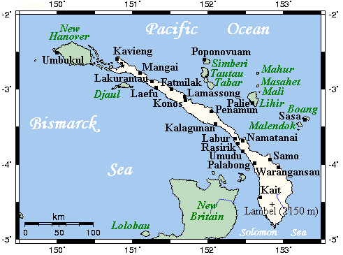
English: A map showing main towns and volcanoes of New Ireland, Bismarck Archipelago, Papau New Guinea
|
| ⧼wm-license-information-date⧽ | not specified |
| ⧼wm-license-information-source⧽ | This map's source is here, with the uploader's modifications, and the GMT homepage says that the tools are released under the GNU General Public License |
| ⧼wm-license-information-author⧽ | Kelisi at en.wikipedia |
ترخيص
قالب:GFDL-user-en-with-disclaimers
قالب:Original upload log
All following user names refer to en.wikipedia.
- 2007-07-21 23:37 Kelisi 491×349×8 (13 KB) (== Summary == A map showing New Ireland's main towns and nearby islands. This map's source is [http://www.aquarius.ifm-geomar.de/ here], with the uploader's modifications, and the [http://gmt.soest.hawaii.edu/ GMT homepage] says that the tools are release)
تاريخ الملف
اضغط على زمن/تاريخ لرؤية الملف كما بدا في هذا الزمن.
| زمن/تاريخ | صورة مصغرة | الأبعاد | مستخدم | تعليق | |
|---|---|---|---|---|---|
| حالي | ★ مراجعة معتمدة 07:54، 7 نوفمبر 2023 | | 491 × 365 (13 كيلوبايت) | Pastakhov (نقاش | مساهمات) | Upload https://upload.wikimedia.org/wikipedia/commons/4/4d/NewIrelandOMC.png |
لا يمكنك استبدال هذا الملف.
وصلات
لا يوجد صفحات تصل لهذه الصورة.