ملف:NJT railmap infobox.svg

حجم معاينة PNG لذلك الملف ذي الامتداد SVG: 329 × 600 بكسل. البعد الآخر: 1٬123 × 2٬048 بكسل.
الملف الأصلي (ملف SVG، أبعاده 2٬720 × 4٬960 بكسل، حجم الملف: 768 كيلوبايت)
| ⧼wm-license-information-description⧽ |
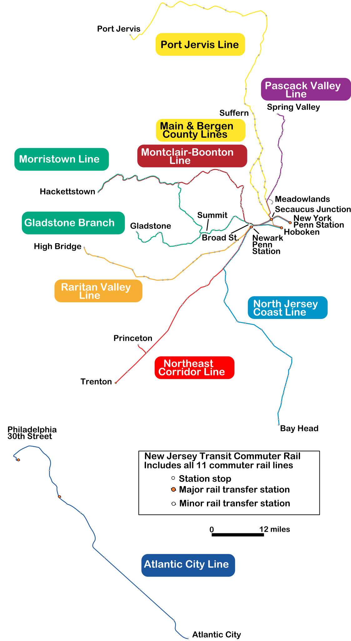
A map of New Jersey Transit's commuter rail routes; originally created by tracing a non-copyrighted NJDOT map in Inkscape. IMPORTANT: This is a version with only the terminal station names, designed for readability in an infobox. For the full map, see File:NJT railmap.svg. |
| ⧼wm-license-information-date⧽ | 2011-07-16 19:34 (UTC) |
| ⧼wm-license-information-source⧽ | |
| ⧼wm-license-information-author⧽ |
|
| [This is a retouched picture, which means that it has been digitally altered from its original version. Modifications: removed stations; enlarged text for infobox readability. The original can be viewed here: NJT_railmap.svg. Modifications made by Pi.1415926535.] Error: {{Lang}}: text has italic markup (help)
|
|

قالب:Original upload log
This image is a derivative work of the following images:
- File:NJT_railmap.svg licensed with GFDL, GFDL-CC-triple
- 2011-07-16T18:36:31Z Pi.1415926535 2720x4960 (299161 Bytes) Corrected geographic route of Meadowlands Rail Line; changed Princeton Junction to official name
- 2010-01-15T00:49:17Z Mitchazenia 2720x4960 (299351 Bytes) Some cosmetics had some problems
- 2010-01-15T00:40:28Z Mitchazenia 2720x4960 (299841 Bytes) update for Great Notch, some cosmetics
- 2009-09-26T22:02:53Z Mitchazenia 2720x4960 (302541 Bytes) Meadowlands
- 2009-09-20T21:48:49Z Mitchazenia 2720x4960 (302590 Bytes) fix
- 2009-09-19T13:35:37Z Mitchazenia 2720x4960 (301926 Bytes) Upload with 1. Removal of Finderne station 2. Adding of Wayne-Route 23 3. Adding of Meadowlands Rail Station 4. Adding of Mount Arlington Rail Station 5. Signed name of Princeton Junction
- 2009-09-19T02:47:06Z Oknazevad 2720x4960 (299946 Bytes) Reverted to version as of 20:12, 5 August 2006, new map of limited interest, prone to crystal balling
- 2009-09-19T01:38:28Z Mitchazenia 2720x4960 (3561101 Bytes) :|
- 2009-09-19T01:35:28Z Mitchazenia 2720x4960 (3561101 Bytes) Changes since August 2006 :|
- 2006-08-05T20:12:46Z Lensovet 2720x4960 (299946 Bytes) make lines significantly thicker; enlarge legend
- 2006-08-05T08:07:57Z Lensovet 2720x4960 (299425 Bytes) fix station legend
- 2006-08-05T07:59:56Z Lensovet 2720x4960 (299491 Bytes) A map of [[w:NJ Transit|]]'s commuter rail routes. Created by me by tracing over a non-copyrighted [[w:NJDOT|]] railroads map in Inkscape. ==Licensing== {{lensovet}} [[Category:Maps of New Jersey]] [[Category:New Jersey Tra
تاريخ الملف
اضغط على زمن/تاريخ لرؤية الملف كما بدا في هذا الزمن.
| زمن/تاريخ | صورة مصغرة | الأبعاد | مستخدم | تعليق | |
|---|---|---|---|---|---|
| حالي | ★ مراجعة معتمدة 06:35، 28 أكتوبر 2023 | | 2٬720 × 4٬960 (768 كيلوبايت) | Pastakhov (نقاش | مساهمات) | Upload https://upload.wikimedia.org/wikipedia/commons/4/4c/NJT_railmap_infobox.svg |
لا يمكنك استبدال هذا الملف.
وصلات
لا يوجد صفحات تصل لهذه الصورة.