ملف:NEPTUNE Canada overview map.jpg
لا توجد دقة أعلى متوفرة.
NEPTUNE_Canada_overview_map.jpg (544 × 445 بكسل حجم الملف: 220 كيلوبايت، نوع MIME: image/jpeg)
| ⧼wm-license-information-description⧽ |
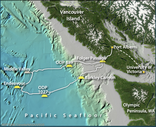
English: This is an overview map, which shows the node locations in the NEPTUNE Canada ocean observatory in the Northeast Pacific Ocean.
Original title: "NEPTUNE Canada network west of Vancouver Island, British Columbia" |
||
| ⧼wm-license-information-date⧽ | قالب:Original upload date | ||
| ⧼wm-license-information-source⧽ | Transferred from en.wikipedia Original uploader was Nerdondo, moved to Commons by Ianusius Original source: The map was created by NEPTUNE Canada by combining and annotating public domain data from NASA and USGS sources Apparently the real source is: http://www.neptunecanada.ca/sensors-instruments/locations/ → http://www.neptunecanada.ca/content-files/flash/basemap.swf |
||
| ⧼wm-license-information-author⧽ | NEPTUNE Canada using work of the United States Federal Government | ||
| ⧼wm-license-information-permission⧽ (⧼wm-license-information-permission-reusing-text⧽) |
|
قالب:Original upload log
قالب:Original description page
- 2009-01-06 19:23 Nerdondo 544×445× (225706 bytes) This is an overview map, which shows the node locations in the NEPTUNE Canada ocean observatory in the Northeast Pacific Ocean. The map was created by NEPTUNE Canada by combining and annotating public domain data from NASA and USGS sources.
تاريخ الملف
اضغط على زمن/تاريخ لرؤية الملف كما بدا في هذا الزمن.
| زمن/تاريخ | صورة مصغرة | الأبعاد | مستخدم | تعليق | |
|---|---|---|---|---|---|
| حالي | ★ مراجعة معتمدة 11:48، 12 يناير 2024 | | 544 × 445 (220 كيلوبايت) | Pastakhov (نقاش | مساهمات) | Upload https://upload.wikimedia.org/wikipedia/commons/d/d1/NEPTUNE_Canada_overview_map.jpg |
لا يمكنك استبدال هذا الملف.
وصلات
لا يوجد صفحات تصل لهذه الصورة.