ملف:NASA Michoud Katrina Flooding.jpg
لا توجد دقة أعلى متوفرة.
NASA_Michoud_Katrina_Flooding.jpg (640 × 480 بكسل حجم الملف: 121 كيلوبايت، نوع MIME: image/jpeg)
وصف قصير
| ⧼wm-license-information-description⧽ |
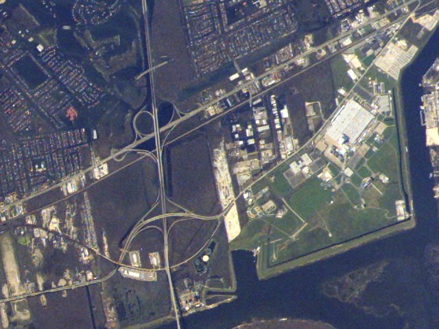
English: NASA Michoud Assembly Facility is located at right center of this image acquired from the International Space Station on September 8, 2005, of areas damaged by Hurricane Katrina. While the facility itself is largely dry, the adjacent neighborhoods are extensively flooded (dark greenish brown regions to the left and right of I-510, left of image center); portions of the highway cloverleaf are also inundated. Image is cropped from the parent frame, ISS011-E-12527 and is oriented with north to the top.
The highway seen running vertically in the photo just left of center is Interstate 510. U.S. Highway 90 crosses it at center left of photo. At bottom, the "Green Bridge" continues the route over the MRGO / Intracoastal Canal. At bottom right is the "V" where the MRGO and Intracoastal canals join; the Intracoastal continues east off to the right while the MRGO heads down to the Gulf at bottom.
|
| ⧼wm-license-information-date⧽ | 2005 |
| ⧼wm-license-information-source⧽ | http://www.nasa.gov/images/content/133647main_jsc2005e37991_low.jpg |
| ⧼wm-license-information-author⧽ | NASA |
| ⧼wm-license-information-permission⧽ (⧼wm-license-information-permission-reusing-text⧽) |
Public Domain |
30°1′19″N 89°55′7.7″W / 30.02194°N 89.918806°W
ترخيص
تاريخ الملف
اضغط على زمن/تاريخ لرؤية الملف كما بدا في هذا الزمن.
| زمن/تاريخ | صورة مصغرة | الأبعاد | مستخدم | تعليق | |
|---|---|---|---|---|---|
| حالي | ★ مراجعة معتمدة 03:35، 29 نوفمبر 2023 | | 640 × 480 (121 كيلوبايت) | Pastakhov (نقاش | مساهمات) | Upload https://upload.wikimedia.org/wikipedia/commons/3/33/NASA_Michoud_Katrina_Flooding.jpg |
لا يمكنك استبدال هذا الملف.
وصلات
لا يوجد صفحات تصل لهذه الصورة.