ملف:NASA Elbe flood 2002 before after.jpg
حجم هذه المعاينة: 571 × 600 بكسل. البعدان الآخران: 1٬950 × 2٬048 بكسل | 2٬856 × 3٬000 بكسل.
الملف الأصلي (2٬856 × 3٬000 بكسل حجم الملف: 2٫96 ميجابايت، نوع MIME: image/jpeg)
| ⧼wm-license-information-description⧽ |
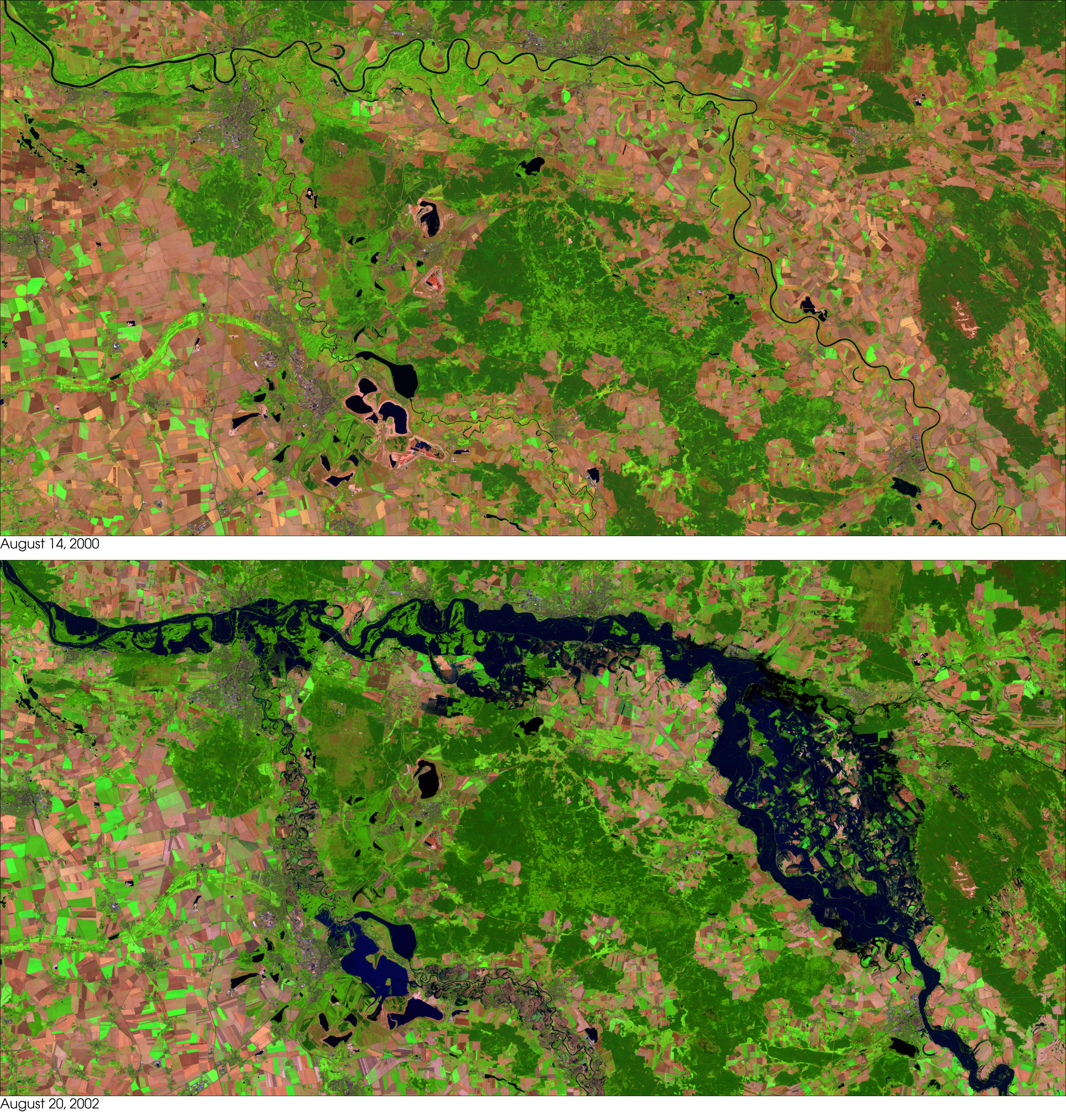
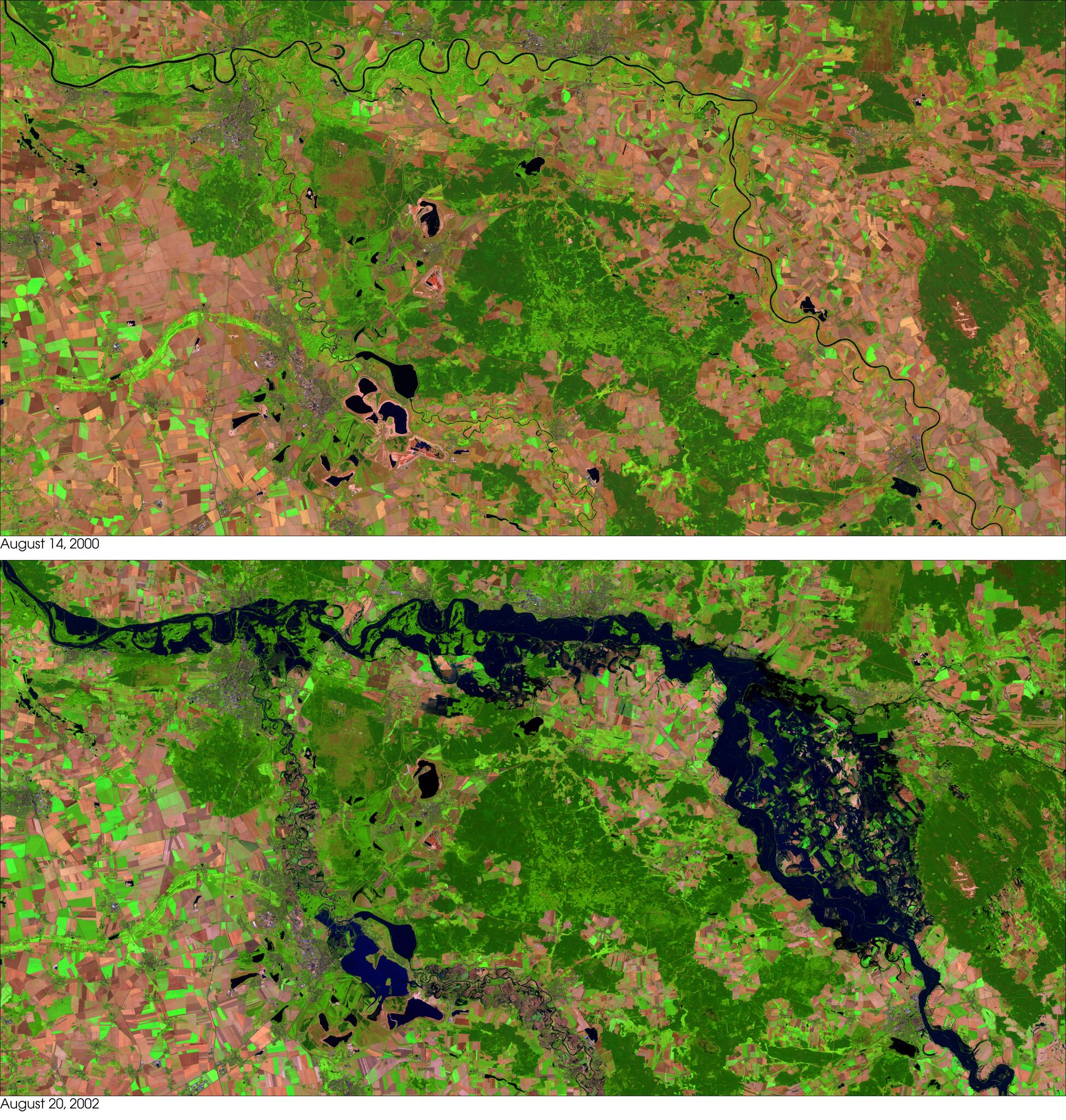
This false-color image of the Elbe River and its tributaries (bottom) was taken on August 20, 2002, by the Enhanced Thematic Mapper plus (ETM+), flying aboard the landsat.gsfc.nasa.gov/ Landsat 7 satellite. As can be seen, the river resembles a fairly large lake on the right-hand side of the image just south of the town of Wittenberg and the River Elbe between Torgau and Aken. |
| ⧼wm-license-information-date⧽ | 2002 |
| ⧼wm-license-information-source⧽ | http://visibleearth.nasa.gov/view_detail.php?id=3584 |
| ⧼wm-license-information-author⧽ | NASA Identifier: elbe_ls7_2002232, first upload: April 15, 2006 - de:Wikipedia by user:Merops |
derivative works
تاريخ الملف
اضغط على زمن/تاريخ لرؤية الملف كما بدا في هذا الزمن.
| زمن/تاريخ | صورة مصغرة | الأبعاد | مستخدم | تعليق | |
|---|---|---|---|---|---|
| حالي | ★ مراجعة معتمدة 14:10، 18 أكتوبر 2023 | | 2٬856 × 3٬000 (2٫96 ميجابايت) | Pastakhov (نقاش | مساهمات) | Upload https://upload.wikimedia.org/wikipedia/commons/a/a8/NASA_Elbe_flood_2002_before_after.jpg |
لا يمكنك استبدال هذا الملف.
وصلات
لا يوجد صفحات تصل لهذه الصورة.
معلومات الصورة (ميتا)
تصنيفات:
- صور ناسا
- Elbe in Torgau
- Elbe flood 2002
- Dommitzsch
- Elbe flood 2002 in Prettin
- Pretzsch (Elbe)
- Elbe Flood 2002 in Elster (Elbe)
- Satellite pictures of Elster (Elbe)
- Elbe in Wittenberg
- Elbe in Coswig (Anhalt)
- Elbe in Dessau-Roßlau
- Aerial photographs of Dessau-Roßlau
- Before-and-after photographs of natural disasters
- Satellite pictures of rivers of Germany