ملف:Moab 830-es.svg

حجم معاينة PNG لذلك الملف ذي الامتداد SVG: 514 × 600 بكسل. البعد الآخر: 1٬755 × 2٬048 بكسل.
الملف الأصلي (ملف SVG، أبعاده 605 × 706 بكسل، حجم الملف: 63 كيلوبايت)
| ⧼wm-license-information-description⧽ |
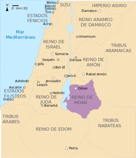
English: Map of Moab in the ninth century BC.
Español: Mapa de Moab en el siglo IX a. C.
|
| ⧼wm-license-information-date⧽ | 2010-07-13 11:25 (UTC) |
| ⧼wm-license-information-source⧽ | |
| ⧼wm-license-information-author⧽ |
|
| ⧼wm-license-information-other-versions⧽ |
قالب:Other versions/Kingdoms around Israel 830 map قالب:DerivativeVersions
|


|

قالب:Original upload log
This image is a derivative work of the following images:
- File:Kingdoms_of_Israel_and_Judah_map_830.svg licensed with Cc-by-sa-3.0, GFDL
- 2010-07-13T10:51:49Z Richardprins 720x859 (80858 Bytes) Added colors for the two kingdoms and converted their text to path and arial
- 2010-07-12T23:53:35Z Richardprins 720x859 (63843 Bytes) Shrinked down the borders
- 2010-07-12T19:43:31Z Richardprins 720x859 (63800 Bytes) {{Information |Description={{en|1=Map showing the ancient levant borders and ancient cities such as [[Urmomium]] and [[Jerash]]. The map also shows the region in the 9th century BCE. Notice the coastal land of Philistia, from
تاريخ الملف
اضغط على زمن/تاريخ لرؤية الملف كما بدا في هذا الزمن.
| زمن/تاريخ | صورة مصغرة | الأبعاد | مستخدم | تعليق | |
|---|---|---|---|---|---|
| حالي | ★ مراجعة معتمدة 18:11، 26 أكتوبر 2023 | | 605 × 706 (63 كيلوبايت) | Pastakhov (نقاش | مساهمات) | Upload https://upload.wikimedia.org/wikipedia/commons/8/81/Moab_830-es.svg |
لا يمكنك استبدال هذا الملف.
وصلات
لا يوجد صفحات تصل لهذه الصورة.