ملف:Mississippi watershed map 1.jpg
لا توجد دقة أعلى متوفرة.
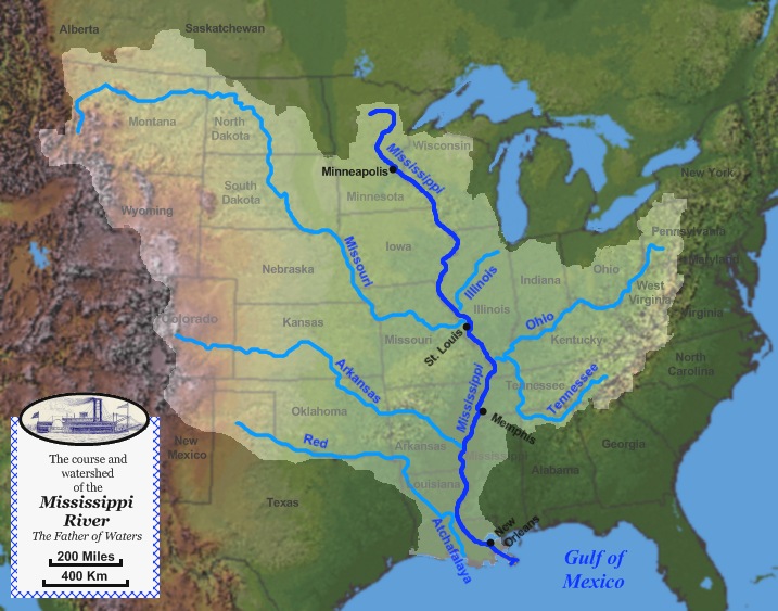
Mississippi_watershed_map_1.jpg (717 × 563 بكسل حجم الملف: 130 كيلوبايت، نوع MIME: image/jpeg)
وصف قصير
| ⧼wm-license-information-description⧽ |
English: Map of the course, watershed, and major tributaries of the Mississippi River.
|
| ⧼wm-license-information-date⧽ | 2010 |
| ⧼wm-license-information-source⧽ | Base map used was taken from the National Atlas, watershed map was from this site from the United States Geological Survey. The picture of the steamboat Robert E. Lee was from this file, which is public domain due to its age. The remaining work was done by the uploader. |
| ⧼wm-license-information-author⧽ | Jon Platek |
ترخيص
|

.jpg&action=edit&redlink=1)
تاريخ الملف
اضغط على زمن/تاريخ لرؤية الملف كما بدا في هذا الزمن.
| زمن/تاريخ | صورة مصغرة | الأبعاد | مستخدم | تعليق | |
|---|---|---|---|---|---|
| حالي | ★ مراجعة معتمدة 00:53، 15 أكتوبر 2023 | | 717 × 563 (130 كيلوبايت) | Pastakhov (نقاش | مساهمات) | Upload https://upload.wikimedia.org/wikipedia/commons/8/80/Mississippi_watershed_map_1.jpg |
لا يمكنك استبدال هذا الملف.
وصلات
لا يوجد صفحات تصل لهذه الصورة.