ملف:Melbourne railways map.gif
حجم هذه المعاينة: 548 × 599 بكسل. البعد الآخر: 2٬126 × 2٬325 بكسل.
الملف الأصلي (2٬126 × 2٬325 بكسل حجم الملف: 213 كيلوبايت، نوع MIME: image/gif، 0٫1ث)
وصف قصير
| ⧼wm-license-information-description⧽ |
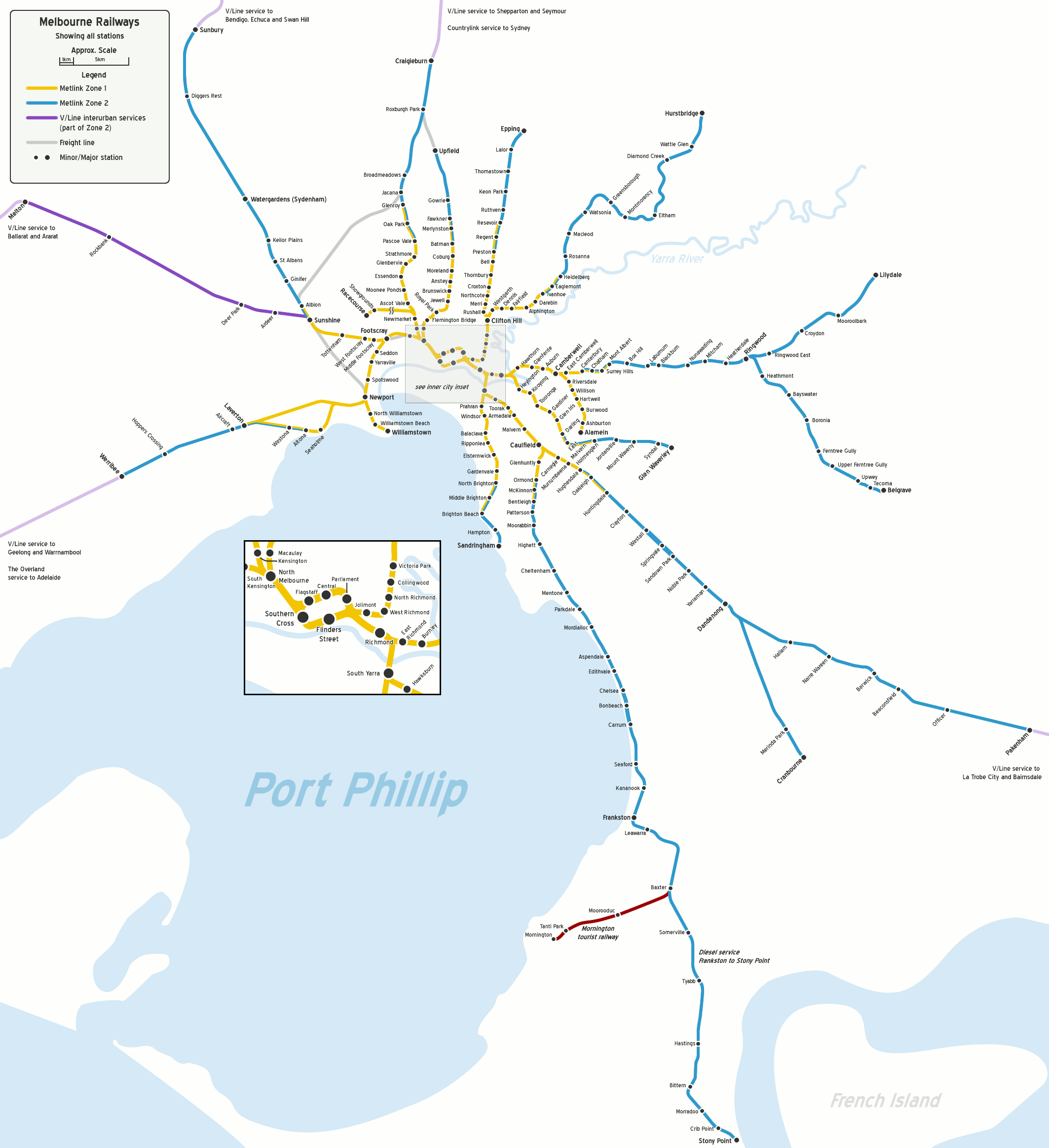
English: Map of Melbourne's railway network, geographically accurate, to approximate scale. Shows all stations.
|
| ⧼wm-license-information-date⧽ | 2006 |
| ⧼wm-license-information-source⧽ | ⧼Wm-license-own-work⧽ |
| ⧼wm-license-information-author⧽ | John Shadbolt |
| ⧼wm-license-information-other-versions⧽ |

|
[All images in this gallery should be recreated using vector graphics as an SVG file. This has several advantages; see Commons:Media for cleanup for more information. If an SVG form of this image is already available, please upload it. After uploading an SVG, replace this template with {{vector version available|new image name.svg}}.] Error: {{Lang}}: text has italic markup (help) |
|
العربية | български | català | čeština | dansk | Deutsch | English | Esperanto | español | français | galego | 한국어 | italiano | magyar | lietuvių | 日本語 | Plattdüütsch | Nederlands | norsk | polski | português | română | русский | suomi | svenska | Türkçe | українська | 中文(繁體) | 中文(简体) | +/− | |
ترخيص
قالب:Original upload log
قالب:Transferred from قالب:Original description page
- 2007-10-18 06:33 JohnnoShadbolt 2126×2325× (209777 bytes) {{Information |Description=Map of [[Melbourne|Melbourne's]] railway network, geographically accurate, to approximate scale. Shows all stations. |Source=Own work. |Date=18th October, 2007 |Author=[[User:JohnnoShadbolt|John Shadbolt]] |Permission= |other_ve
- 2007-03-06 04:53 JohnnoShadbolt 2126×2325× (179878 bytes) {{Information |Description=Map of [[Melbourne|Melbourne's]] railway network, geographically accurate, to approximate scale. Shows all stations. |Source=Own work. |Date=31st December, 2006 (updated 6th March, 2007) |Author=[[User:JohnnoShadbolt|John Shadbo
- 2006-12-31 06:46 JohnnoShadbolt 2126×2325× (179845 bytes) {{Information |Description=Map of [[Melbourne|Melbourne's]] railway network, geographically accurate, to approximate scale. Shows all stations. |Source=Own work. |Date=31st December, 2006 |Author=[[User:JohnnoShadbolt|John Shadbolt]] |Permission= |other_v
تاريخ الملف
اضغط على زمن/تاريخ لرؤية الملف كما بدا في هذا الزمن.
| زمن/تاريخ | صورة مصغرة | الأبعاد | مستخدم | تعليق | |
|---|---|---|---|---|---|
| حالي | ★ مراجعة معتمدة 23:27، 2 نوفمبر 2023 | | 2٬126 × 2٬325 (213 كيلوبايت) | Pastakhov (نقاش | مساهمات) | Upload https://upload.wikimedia.org/wikipedia/commons/8/89/Melbourne_railways_map.gif |
لا يمكنك استبدال هذا الملف.
وصلات
لا يوجد صفحات تصل لهذه الصورة.