ملف:Mediterranean heatwave ESA23380840.jpeg
حجم هذه المعاينة: 600 × 600 بكسل. البعد الآخر: 1٬920 × 1٬920 بكسل.
الملف الأصلي (1٬920 × 1٬920 بكسل حجم الملف: 2٫38 ميجابايت، نوع MIME: image/jpeg)
وصف قصير
| ⧼wm-license-information-description⧽ |
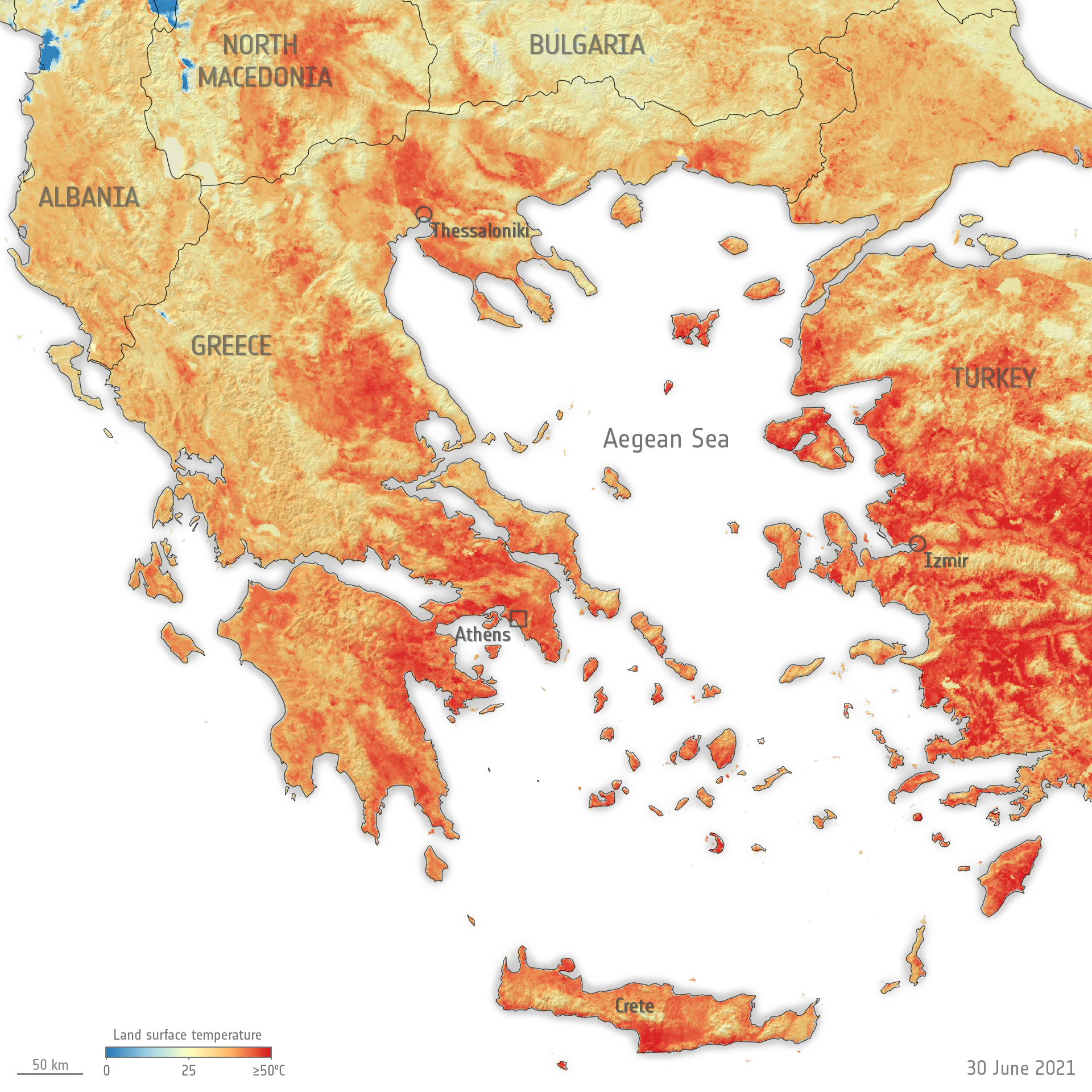
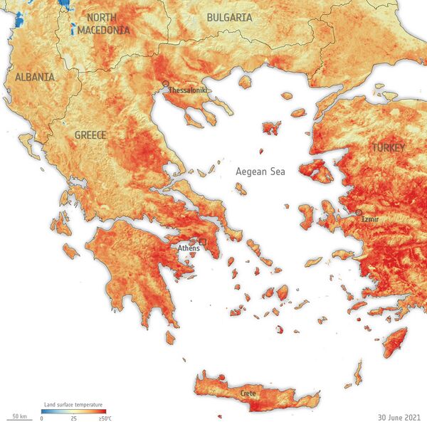
English: Scorching temperatures hit both Greece and Turkey this week, leading to the temporary closure of the Acropolis – Greece’s most visited monument.
This map shows the land surface temperature of Greece and surrounding countries on 30 June. The data show that surface temperatures reached over 50°C in many locations including the northwest of Athens and many regions in Turkey. The blue spots visible near Albania are clouds. The map has been generated using the Copernicus Sentinel-3’s Sea and Land Surface Temperature Radiometer. Whereas weather forecasts use predicted air temperatures, the satellite measures the real amount of energy radiating from Earth – therefore this map better represents the real temperature of the land surface. |
| ⧼wm-license-information-date⧽ | قالب:Upload date |
| ⧼wm-license-information-source⧽ | Mediterranean heatwave |
| ⧼wm-license-information-author⧽ | European Space Agency |
| Activity | Observing the Earth |
| Mission | Sentinel-3 |
| System | Copernicus |
ترخيص
تاريخ الملف
اضغط على زمن/تاريخ لرؤية الملف كما بدا في هذا الزمن.
| زمن/تاريخ | صورة مصغرة | الأبعاد | مستخدم | تعليق | |
|---|---|---|---|---|---|
| حالي | ★ مراجعة معتمدة 22:06، 30 أكتوبر 2023 | | 1٬920 × 1٬920 (2٫38 ميجابايت) | Pastakhov (نقاش | مساهمات) | Upload https://upload.wikimedia.org/wikipedia/commons/a/a7/Mediterranean_heatwave_ESA23380840.jpeg |
لا يمكنك استبدال هذا الملف.
وصلات
لا يوجد صفحات تصل لهذه الصورة.
تصنيفات:
- Spacemedia files uploaded by OptimusPrimeBot
- Land surface temperature maps
- Sentinel-3 images
- Satellite pictures of Greece
- Weather and climate of Greece
- 2021 in Greece
- Satellite pictures of Turkey
- Maps of weather and climate of Turkey
- June 2021 in Turkey
- Satellite pictures of Bulgaria
- Weather and climate of Bulgaria
- 2021 in Bulgaria
- Satellite pictures of Albania
- Weather and climate of Albania
- 2021 in Albania
- Satellite pictures of North Macedonia
- Weather and climate of North Macedonia
- 2021 in North Macedonia