ملف:Marks Mills Battlefield Arkansas.jpg

حجم هذه المعاينة: 785 × 600 بكسل. البعد الآخر: 1٬820 × 1٬390 بكسل.
الملف الأصلي (1٬820 × 1٬390 بكسل حجم الملف: 1٫02 ميجابايت، نوع MIME: image/jpeg)
وصف قصير
| ⧼wm-license-information-description⧽ |
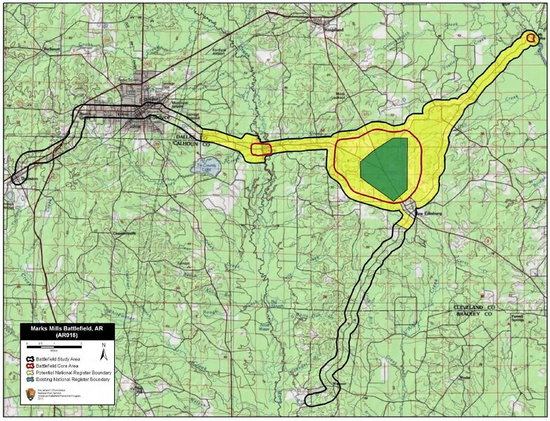
English: Map of battlefield core and study areas.
The 1993 Study Area boundary was a generic polygon that, while encompassing the battle, did not accurately reflect the battlefield. The ABPP significantly reduced the Study Area to more accurately reflect troop movements, areas of fighting, and historic road alignments. The ABPP has redrawn the Study Area to more accurately reflect BG Joseph O. Shelby's approach to the battlefield from the north and east, other approach and withdrawal routes, and troop movements. The 1993 Core Area was reshaped to more accurately reflect areas of fighting. In addition, two other Core Areas were added to the Study Area. The small easternmost Core Area represents the 1st Missouri Cavalry Battalion's capture of the Union held Saline River crossing at Mount Elba. The westernmost Core Area represents the fight at Moro Creek between the 1st Iowa Cavalry and Hunter's Missouri Cavalry Regiment. The Confederates failed in their attempt to capture the Federal horsemen at Moro Creek. |
| ⧼wm-license-information-date⧽ | 2011 |
| ⧼wm-license-information-source⧽ | National Park Service |
| ⧼wm-license-information-author⧽ | American Battlefield Protection Program |
ترخيص
تاريخ الملف
اضغط على زمن/تاريخ لرؤية الملف كما بدا في هذا الزمن.
| زمن/تاريخ | صورة مصغرة | الأبعاد | مستخدم | تعليق | |
|---|---|---|---|---|---|
| حالي | ★ مراجعة معتمدة 07:33، 3 ديسمبر 2023 | | 1٬820 × 1٬390 (1٫02 ميجابايت) | Pastakhov (نقاش | مساهمات) | Upload https://upload.wikimedia.org/wikipedia/commons/7/73/Marks_Mills_Battlefield_Arkansas.jpg |
لا يمكنك استبدال هذا الملف.
وصلات
لا يوجد صفحات تصل لهذه الصورة.