ملف:Mapa político de España, 1850.jpg
الملف الأصلي (1٬800 × 1٬322 بكسل حجم الملف: 399 كيلوبايت، نوع MIME: image/jpeg)
وصف قصير
Source
This map comes from:
- Francisco Jorge Torres Villegas, Cartografía hispano-científica ó sea los mapas españoles en que se representa bajo sus diferentes fases. Imprenta de don José María Alonso, 1852 (1ª ed.) y 1857 (2ª ed.).
- (Spanish Scientific cartography, that is the Maps about Spain in which it is represented its evolution. Printed by Mr. Jose Maria Alonso, 1852 and 1857, two eds.)
This copy is from the Spanish National Library in Madrid (Link to entry in the Catalogue). Original link Wayback Machine.
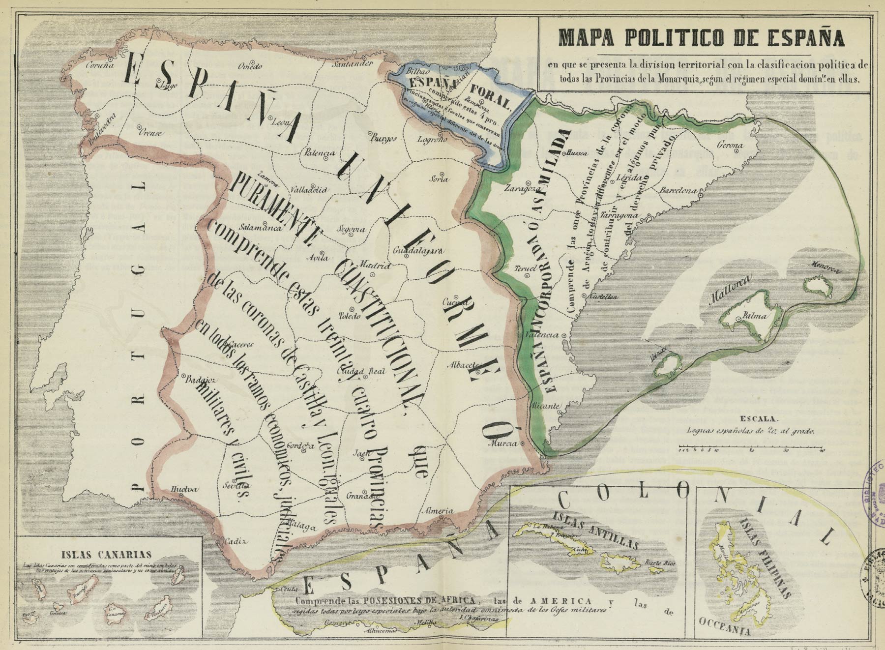
Text on the map
Top (Title)
«Mapa de España en que se presenta la división territorial con la clasificación de todas las Provincias de la Monarquía según el régimen legal especial común en ellos».
Orange-surrounded area
«España Uniforme ó Puramente Constitucional que comprende estas treinta y cuatro Provincias de las coronas de Castilla y León, iguales en todos los ramos económicos, judiciales, militares y civiles».
Former kingdoms of Castile, León and Granada.
Green-surrounded area
«España Incorporada ó Asimilada que comprende las once provincias de la Corona de Aragón, todavía diferentes en el modo de contribuir y en algunos puntos del derecho privado».
Crown of Aragón
Blue-surrounded area
«España Foral».
Navarre and the Provincias Vascongadas
Overseas
«España Colonial».
تاريخ الملف
اضغط على زمن/تاريخ لرؤية الملف كما بدا في هذا الزمن.
| زمن/تاريخ | صورة مصغرة | الأبعاد | مستخدم | تعليق | |
|---|---|---|---|---|---|
| حالي | ★ مراجعة معتمدة 04:46، 7 نوفمبر 2023 | | 1٬800 × 1٬322 (399 كيلوبايت) | Pastakhov (نقاش | مساهمات) | Upload https://upload.wikimedia.org/wikipedia/commons/8/82/Mapa_pol%C3%ADtico_de_Espa%C3%B1a%2C_1850.jpg |
لا يمكنك استبدال هذا الملف.
وصلات
لا يوجد صفحات تصل لهذه الصورة.