ملف:Map of alaska volcanoes cleveland.jpg
لا توجد دقة أعلى متوفرة.
Map_of_alaska_volcanoes_cleveland.jpg (640 × 456 بكسل حجم الملف: 226 كيلوبايت، نوع MIME: image/jpeg)
وصف قصير
| ⧼wm-license-information-description⧽ |
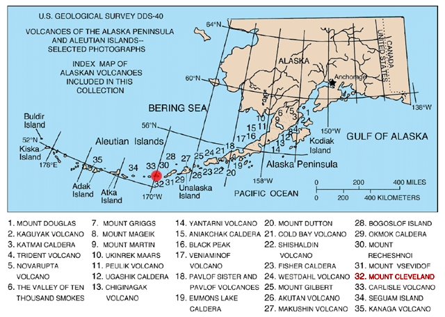
English: Map of volcanoes of the Alaska Peninsula and Aleutian Islands
|
| ⧼wm-license-information-date⧽ | |
| ⧼wm-license-information-source⧽ | http://geopubs.wr.usgs.gov/dds/dds-40/ |
| ⧼wm-license-information-author⧽ | U.S. Geological Survey |
ترخيص
This image is a work of a United States Geological Survey employee, taken or made during the course of the person's official duties. As a work of the United States Government, the image is in the public domain. For more information, see the USGS copyright policy.
تاريخ الملف
اضغط على زمن/تاريخ لرؤية الملف كما بدا في هذا الزمن.
| زمن/تاريخ | صورة مصغرة | الأبعاد | مستخدم | تعليق | |
|---|---|---|---|---|---|
| حالي | ★ مراجعة معتمدة 04:20، 16 أكتوبر 2023 | | 640 × 456 (226 كيلوبايت) | Pastakhov (نقاش | مساهمات) | Upload https://upload.wikimedia.org/wikipedia/commons/4/45/Map_of_alaska_volcanoes_cleveland.jpg |
لا يمكنك استبدال هذا الملف.
وصلات
لا يوجد صفحات تصل لهذه الصورة.