ملف:Map of Lille metro lines 1 and 2.svg

حجم معاينة PNG لذلك الملف ذي الامتداد SVG: 617 × 600 بكسل. البعد الآخر: 2٬107 × 2٬048 بكسل.
الملف الأصلي (ملف SVG، أبعاده 860 × 836 بكسل، حجم الملف: 212 كيلوبايت)
وصف قصير
| ⧼wm-license-information-description⧽ |
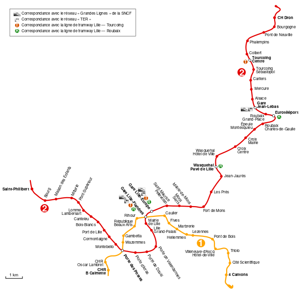
English: Map of Lille Metro lines 1 and 2
Français : Carte des lignes 1 et 2 du métro de Lille
|
| ⧼wm-license-information-date⧽ | 2009 |
| ⧼wm-license-information-source⧽ | ⧼Wm-license-own-work⧽ |
| ⧼wm-license-information-author⧽ | Sardon |
قالب:Atelier graphique carte قالب:Translation possible
ترخيص
|

تاريخ الملف
اضغط على زمن/تاريخ لرؤية الملف كما بدا في هذا الزمن.
| زمن/تاريخ | صورة مصغرة | الأبعاد | مستخدم | تعليق | |
|---|---|---|---|---|---|
| حالي | ★ مراجعة معتمدة 20:53، 15 نوفمبر 2023 | | 860 × 836 (212 كيلوبايت) | Pastakhov (نقاش | مساهمات) | Upload https://upload.wikimedia.org/wikipedia/commons/f/f8/Map_of_Lille_metro_lines_1_and_2.svg |
لا يمكنك استبدال هذا الملف.
وصلات
لا يوجد صفحات تصل لهذه الصورة.