ملف:Map of Ireland's capitals.png

حجم هذه المعاينة: 470 × 599 بكسل. البعد الآخر: 1٬630 × 2٬078 بكسل.
الملف الأصلي (1٬630 × 2٬078 بكسل حجم الملف: 136 كيلوبايت، نوع MIME: image/png)
وصف قصير
| ⧼wm-license-information-description⧽ |
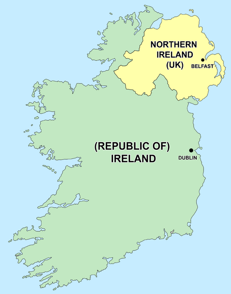
English: Political capitals of the countries Ireland and Northern Ireland (إندونيسية)
|
| ⧼wm-license-information-date⧽ | قالب:Original upload date |
| ⧼wm-license-information-source⧽ | قالب:Transferred from |
| ⧼wm-license-information-author⧽ | قالب:Original uploader |
ترخيص
قالب:Original upload log
- delete all current 21:50, 26 December 2006 Thumbnail for version as of 21:50, 26 December 2006 415×541 (13 KB) Jonto (Talk | contribs | block) (Updated as per talk.)
- delete revert 13:42, 11 October 2006 Thumbnail for version as of 13:42, 11 October 2006 415×541 (11 KB) Evertype (Talk | contribs | block) (I re-coloured the existing map and replaced the text on the island.)
- delete revert 04:08, 11 January 2006 Thumbnail for version as of 04:08, 11 January 2006 415×541 (5 KB) Zscout370 (Talk | contribs | block) (Compression)
- delete revert 07:31, 31 May 2005 Thumbnail for version as of 07:31, 31 May 2005 415×541 (14 KB) WikiDon (Talk | contribs | block)
تاريخ الملف
اضغط على زمن/تاريخ لرؤية الملف كما بدا في هذا الزمن.
| زمن/تاريخ | صورة مصغرة | الأبعاد | مستخدم | تعليق | |
|---|---|---|---|---|---|
| حالي | ★ مراجعة معتمدة 23:56، 14 أكتوبر 2023 | | 1٬630 × 2٬078 (136 كيلوبايت) | Pastakhov (نقاش | مساهمات) | Upload https://upload.wikimedia.org/wikipedia/commons/4/4f/Map_of_Ireland%27s_capitals.png |
لا يمكنك استبدال هذا الملف.
وصلات
لا يوجد صفحات تصل لهذه الصورة.