ملف:Map Gaul divisions 481-de.svg

حجم معاينة PNG لذلك الملف ذي الامتداد SVG: 577 × 599 بكسل. البعد الآخر: 1٬972 × 2٬048 بكسل.
الملف الأصلي (ملف SVG، أبعاده 755 × 784 بكسل، حجم الملف: 103 كيلوبايت)
وصف قصير
| ⧼wm-license-information-description⧽ |
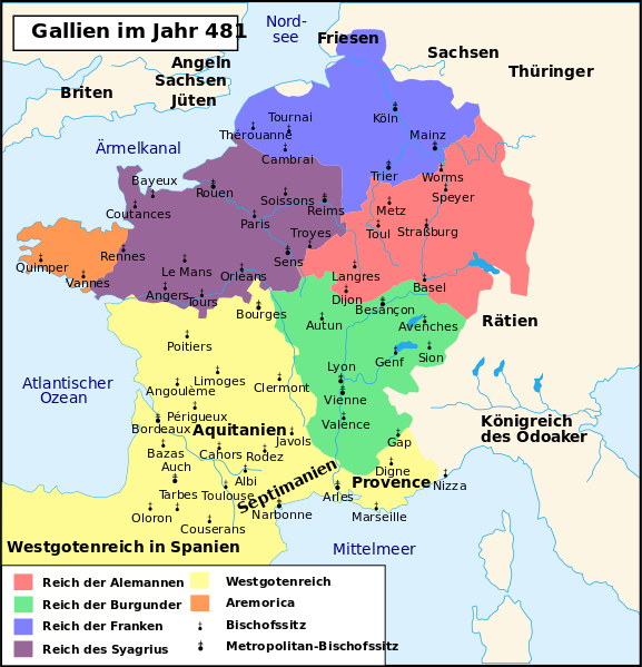
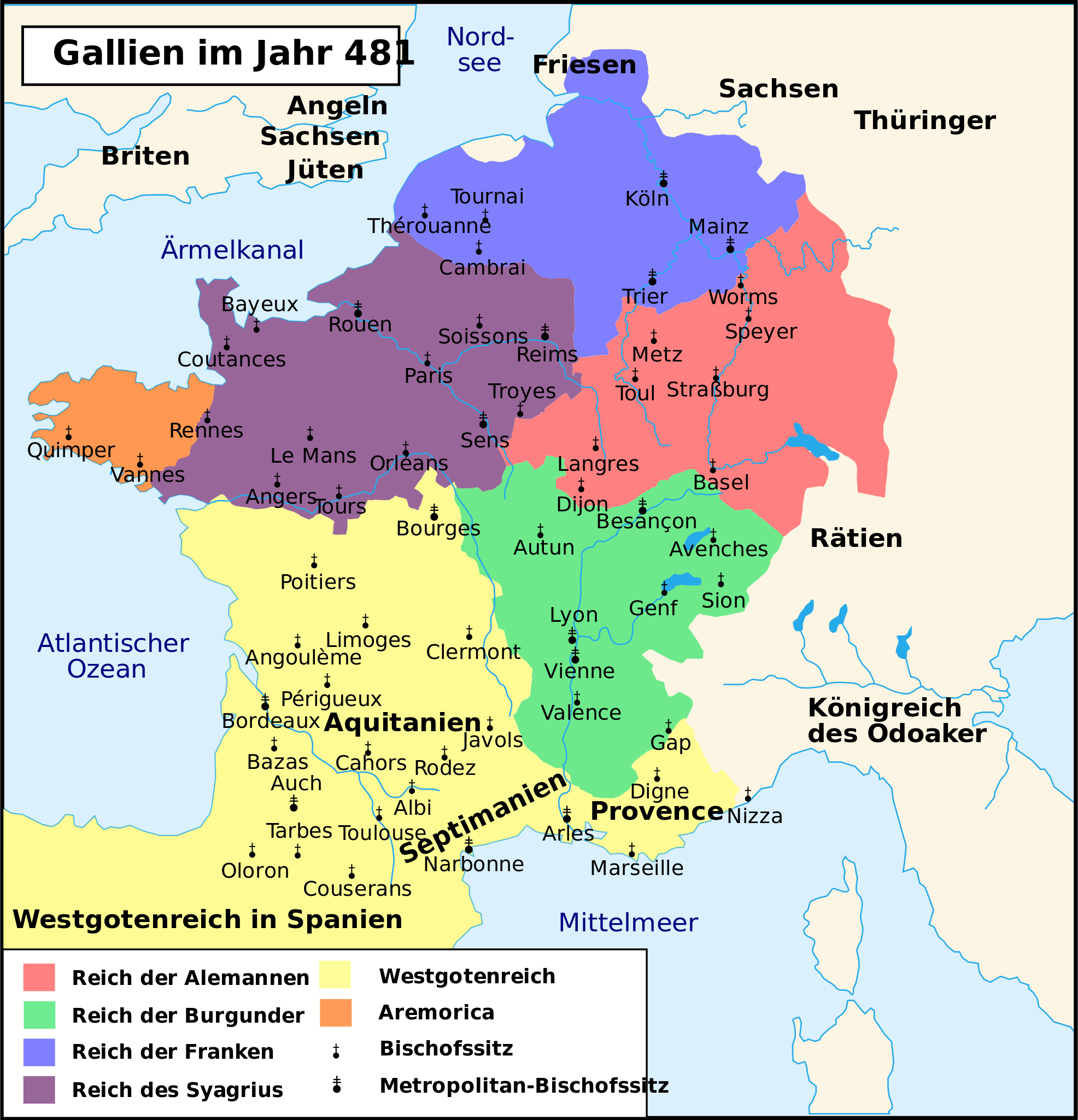
Deutsch: Territoriale Aufteilung Galliens in Jahr 481 n. Chr.
Reich der Alemannen
Reich der Burgunder
Reich der Franken
Westgotenreich
Reich des Syagrius
Aremorica Français : La division de la Gaule en 481.
|
| ⧼wm-license-information-date⧽ | 2010-09-06 08:32 (UTC) |
| ⧼wm-license-information-source⧽ | |
| ⧼wm-license-information-author⧽ |
|
| ⧼wm-license-information-other-versions⧽ |
| [This is a retouched picture, which means that it has been digitally altered from its original version. Modifications: Deutsche Übersetzung / traduction allemand. The original can be viewed here: Map Gaul divisions 481-fr.svg. Modifications made by Furfur.] Error: {{Lang}}: text has italic markup (help)
|
هذه الصورة هي ضمن الملكية عامة بسبب إنتهاء فترة صلاحية حقوقها في الولايات المتحدة الأمريكية و أي دولة أخرى ينص قانونها على مرور 70 سنة كحد أعلى على وفاة المنتج لإنتهاء صلاحية الحقوق.
قالب:Original upload log
This image is a derivative work of the following images:
- File:La_division_de_la_Gaule_en_481.svg licensed with PD-old
- 2010-04-27T20:48:50Z Romain0 755x784 (289302 Bytes) Courts d'eau + légendes.
- 2010-04-06T21:28:15Z Romain0 755x784 (281141 Bytes) Légende.
- 2010-03-27T09:29:13Z Romain0 755x784 (186086 Bytes) Légende.
- 2010-02-24T22:16:00Z Romain0 755x784 (177843 Bytes) Idem.
- 2010-02-24T22:09:36Z Romain0 755x784 (185174 Bytes) Correction légende.
- 2010-02-16T18:17:32Z Romain0 755x784 (185219 Bytes) Caractères.
- 2010-02-16T18:15:37Z Romain0 755x784 (179375 Bytes) Caractères.
- 2010-02-15T21:11:27Z Romain0 755x784 (177265 Bytes) Légende.
- 2010-02-15T21:04:11Z Romain0 755x784 (182690 Bytes) Fleuve.
- 2010-02-15T21:02:50Z Romain0 755x784 (187558 Bytes) allégement.
- 2010-02-15T20:57:18Z Romain0 755x784 (181735 Bytes) {{Information |Description={{fr|1=La division de la Gaule en 481.}} |Source=Travail personnel sur un fond de carte de [[User:Historicair|historicair]] : [[:Image:Blank map of Gaul 1st century BC.svg]]. D'après [[Paul Vidal d
تاريخ الملف
اضغط على زمن/تاريخ لرؤية الملف كما بدا في هذا الزمن.
| زمن/تاريخ | صورة مصغرة | الأبعاد | مستخدم | تعليق | |
|---|---|---|---|---|---|
| حالي | ★ مراجعة معتمدة 17:22، 1 نوفمبر 2023 | | 755 × 784 (103 كيلوبايت) | Pastakhov (نقاش | مساهمات) | Upload https://upload.wikimedia.org/wikipedia/commons/a/ab/Map_Gaul_divisions_481-de.svg |
لا يمكنك استبدال هذا الملف.
وصلات
لا يوجد صفحات تصل لهذه الصورة.