ملف:Map.2009 seagate.campus usf.sarasota-manatee 83d40m in.public.domain .png
الملف الأصلي (950 × 689 بكسل حجم الملف: 235 كيلوبايت، نوع MIME: image/png)

|
[All images in this gallery should be recreated using vector graphics as an SVG file. This has several advantages; see Commons:Media for cleanup for more information. If an SVG form of this image is already available, please upload it. After uploading an SVG, replace this template with {{vector version available|new image name.svg}}.] Error: {{Lang}}: text has italic markup (help) |
|
العربية | български | català | čeština | dansk | Deutsch | English | Esperanto | español | français | galego | 한국어 | italiano | magyar | lietuvių | 日本語 | Plattdüütsch | Nederlands | norsk | polski | português | română | русский | suomi | svenska | Türkçe | українська | 中文(繁體) | 中文(简体) | +/− | |
وصف قصير
| ⧼wm-license-information-description⧽ |
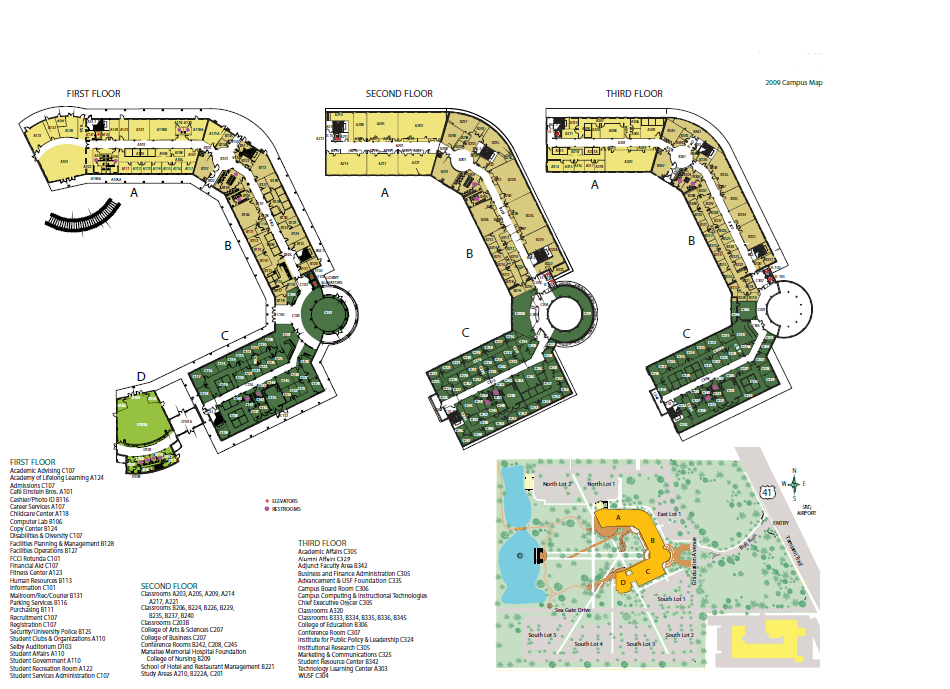
scan of the initial map of the Seagate campus of University of South Florida Sarasota-Manatee from a publicly-available copyright-free document published by this state university; the campus was created on the eastern portion of Seagate, a property platted under that name in the early 1920s on property that had been homesteaded in the 1800s by Elizabeth and Lavanius Dunham, M.D., developed in 1929 by Gwendolyn and Powel Crosley as a fishing camp and elegant winter retreat built on the bay front, purchased and resided in by Mable and Freeman Horton in 1948, a large portion of which was acquired by the state in 1991 after an acquisition campaign by Friends of Seagate and divided into two portions, the western portion being overseen by Manatee County as a historical site and, the eastern portion that became a new satellite campus for USF in Tampa when it separated from the New College campus; the entire property was listed on the National Register of Historic Places in 1982, but contrary to design, the uplands pine forest was cleared for parking lots rather than building the planned parking garage — replaces image uploaded on May 25, 2010 |
| ⧼wm-license-information-date⧽ | 2016 |
| ⧼wm-license-information-source⧽ | a PD-FLGov Florida public document |
| ⧼wm-license-information-author⧽ | 83d40m |
| ⧼wm-license-information-permission⧽ (⧼wm-license-information-permission-reusing-text⧽) |
see below |
ترخيص
تاريخ الملف
اضغط على زمن/تاريخ لرؤية الملف كما بدا في هذا الزمن.
| زمن/تاريخ | صورة مصغرة | الأبعاد | مستخدم | تعليق | |
|---|---|---|---|---|---|
| حالي | ★ مراجعة معتمدة 15:18، 12 نوفمبر 2023 | | 950 × 689 (235 كيلوبايت) | Pastakhov (نقاش | مساهمات) | Upload https://upload.wikimedia.org/wikipedia/commons/4/45/Map.2009_seagate.campus_usf.sarasota-manatee_83d40m_in.public.domain_.png |
لا يمكنك استبدال هذا الملف.
وصلات
لا يوجد صفحات تصل لهذه الصورة.