ملف:Magical Stonehenge - geograph.org.uk - 1628518.jpg
Magical_Stonehenge_-_geograph.org.uk_-_1628518.jpg (640 × 250 بكسل حجم الملف: 23 كيلوبايت، نوع MIME: image/jpeg)
وصف قصير
| ⧼wm-license-information-description⧽ |
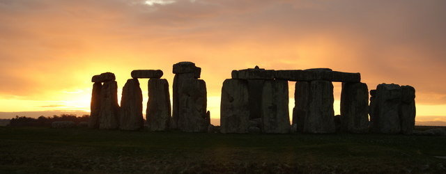
English: Magical Stonehenge Photograph taken at 15.51, during a sunset sequence. 19th December 2009; as close to the winter solstice as I was likely to capture a sunset, according to the weather forecast.
For anyone interested in the technical details: ISO: 100 Aperture: f4 Exposure: 1/80 (under exposed by 0.7 stop) Lens: 35/105mm, set at 40mm Other than cropping, I resisted the temptation to "enhance" the image. http://www.english-heritage.org.uk/server/show/nav.16472 Extract from the English Heritage website: The great and ancient stone circle of Stonehenge is one of the wonders of the world. What visitors see today are the substantial remnants of the last in a sequence of such monuments erected between c. 3000 BC and 1600 BC. The Stonehenge we see today is aligned on the midwinter setting sun and the midsummer sunrise. Stonehenge's orientation in relation to the rising and setting sun has always been one of its most remarkable features. Whether this was because its builders came from a sun worshipping culture or because - as some have asserted - the circle and its banks were part of a huge astronomical calendar, remains a mystery. Evidence of the peoples who built Stonehenge exists through their tools, artefacts, pottery and even the contents of their graves. Some of these are displayed in the museums at Salisbury and Devizes. The first monument at Stonehenge consisted of a circular bank and ditch with a ring of 56 pits now known as the Aubrey Holes. Later monuments all used and reused the stones we see today, many of which were brought from some distance away. The main final phase comprised the construction of an outer circle of huge standing stones - super-hard sarsens, from the Marlborough Downs. These were topped by lintels, forming a ring. Inside this stood a horseshoe of five still-larger constructions, known as trilithons: pairs of uprights with a lintel across each. All the stones were connected using mortise-and-tenon joints. Smaller bluestones, from the Preseli Hills in South Wales, were also arranged in a ring and a horseshoe, within the great circle and horseshoe of sarsen stones. In an earlier phase, these bluestones had been erected in a different arrangement. A World Heritage Site, Stonehenge and all its surroundings remain powerful witnesses to the once great civilisations of the Stone and Bronze Ages which existed here around 3,700 BC to 1600 BC. Stonehenge is surrounded by 1,500 acres of land owned by The National Trust, with excellent walks. |
| ⧼wm-license-information-date⧽ | 2009 |
| ⧼wm-license-information-source⧽ | From geograph.org.uk |
| ⧼wm-license-information-author⧽ | Peter Trimming |
| ⧼wm-license-cc-attribution⧽ (قالب:I18n/Credit line) |
Peter Trimming / Magical Stonehenge / |
51°10′45″N 1°49′31″W / 51.17904°N 1.8253°W قالب:Object location
_heading:247)
ترخيص
تاريخ الملف
اضغط على زمن/تاريخ لرؤية الملف كما بدا في هذا الزمن.
| زمن/تاريخ | صورة مصغرة | الأبعاد | مستخدم | تعليق | |
|---|---|---|---|---|---|
| حالي | ★ مراجعة معتمدة 11:31، 13 أكتوبر 2023 | 640 × 250 (23 كيلوبايت) | Pastakhov (نقاش | مساهمات) | Upload https://upload.wikimedia.org/wikipedia/commons/a/a7/Magical_Stonehenge_-_geograph.org.uk_-_1628518.jpg |
لا يمكنك استبدال هذا الملف.
وصلات
لا يوجد صفحات تصل لهذه الصورة.