ملف:Lyscombe Bottom near Higher Melcombe 1 - geograph.org.uk - 466403.jpg
لا توجد دقة أعلى متوفرة.
Lyscombe_Bottom_near_Higher_Melcombe_1_-_geograph.org.uk_-_466403.jpg (640 × 480 بكسل حجم الملف: 58 كيلوبايت، نوع MIME: image/jpeg)
وصف قصير
| ⧼wm-license-information-description⧽ |
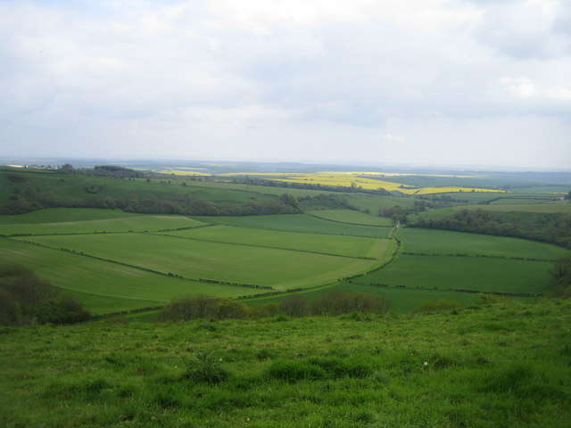
English: Lyscombe Bottom near Higher Melcombe 1 This view from Lyscombe Hill at a height of about 240m and looking south-east is of Lyscombe Bottom. This is a coombe, a steep sided dry valley formed in freely draining chalk downland. Traces of medieval settlement patterns and some barrows (mounds of earth and stones raised over a grave) have been found in Lyscombe Bottom. On the nearby hills are numerous cross dykes, tumuli and a hill fort. In the middle distance two woods almost meet at about 130m, and Lyscombe Farm can just be seen amongst the trees. Barely visible in the far distance beyond the Frome valley are the Purbeck Hills.
|
| ⧼wm-license-information-date⧽ | 2006 |
| ⧼wm-license-information-source⧽ | From geograph.org.uk |
| ⧼wm-license-information-author⧽ | Andy Gryce |
| ⧼wm-license-cc-attribution⧽ (قالب:I18n/Credit line) |
Andy Gryce / Lyscombe Bottom near Higher Melcombe 1 / |
50°49′20″N 2°22′50″W / 50.82236°N 2.3806°W قالب:Object location
_heading:157)
ترخيص
تاريخ الملف
اضغط على زمن/تاريخ لرؤية الملف كما بدا في هذا الزمن.
| زمن/تاريخ | صورة مصغرة | الأبعاد | مستخدم | تعليق | |
|---|---|---|---|---|---|
| حالي | ★ مراجعة معتمدة 11:18، 23 نوفمبر 2023 | | 640 × 480 (58 كيلوبايت) | Pastakhov (نقاش | مساهمات) | Upload https://upload.wikimedia.org/wikipedia/commons/0/0b/Lyscombe_Bottom_near_Higher_Melcombe_1_-_geograph.org.uk_-_466403.jpg |
لا يمكنك استبدال هذا الملف.
وصلات
لا يوجد صفحات تصل لهذه الصورة.