ملف:LatinMonetaryUnion 1866-1914.svg

حجم معاينة PNG لذلك الملف ذي الامتداد SVG: 450 × 456 بكسل. البعد الآخر: 2٬021 × 2٬048 بكسل.
الملف الأصلي (ملف SVG، أبعاده 450 × 456 بكسل، حجم الملف: 452 كيلوبايت)
وصف قصير
| ⧼wm-license-information-description⧽ |
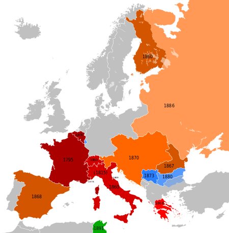
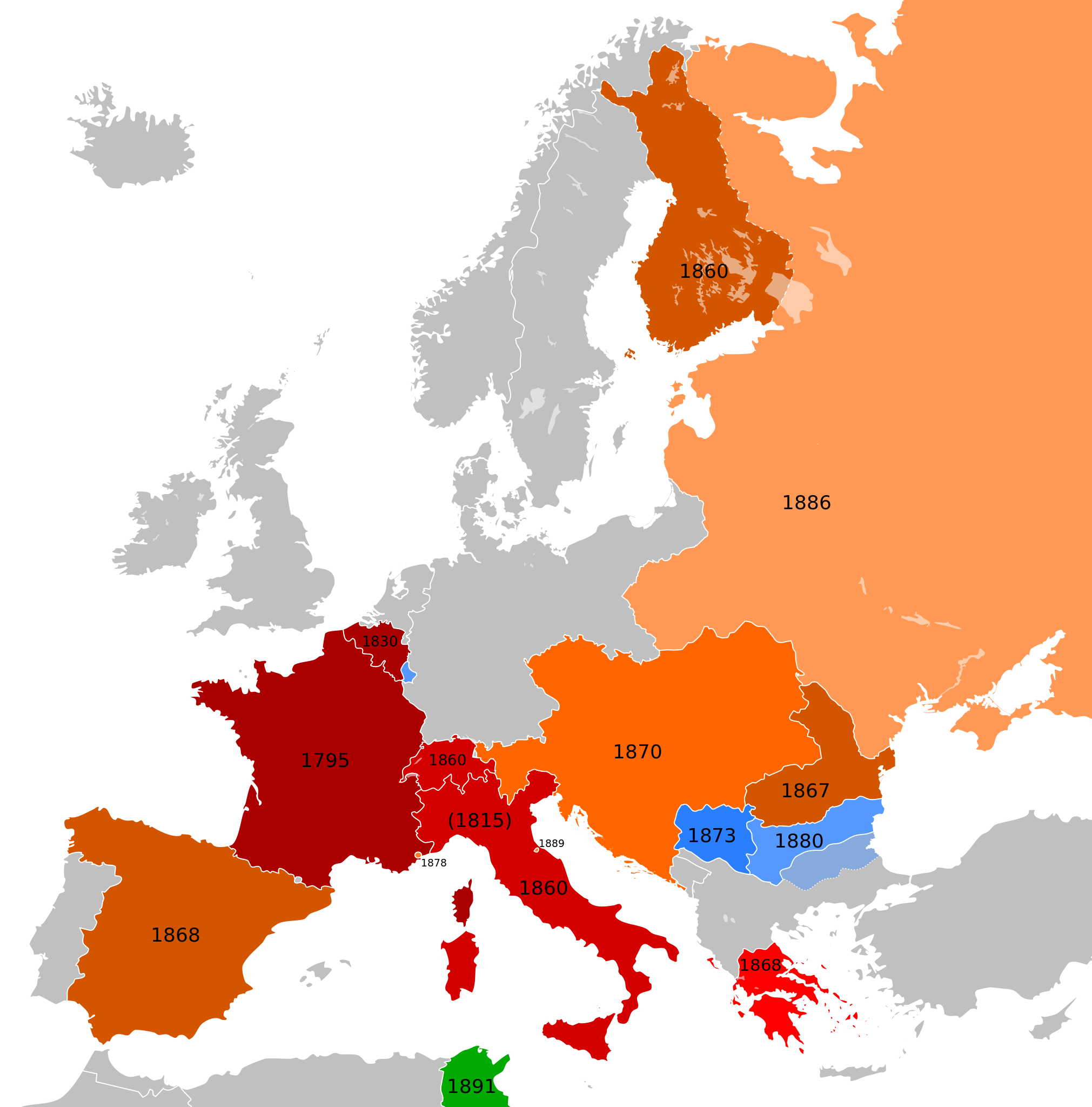
Français : Carte représentant les pays européens participants à l'Union Monétaire Latin entre 1866 et 1914
English: Map showing the European countries participating at the Latin Monetary Union between 1866 and 1914.
Deutsch: Übersicht der europäischen Teilnehmer an der Lateinischen Münzunion zwischen 1866 und 1914.
Die Helligkeit kennzeichnet das ungefähre Beitrittsdatum.
|
||||||||||||||||||||||||
| ⧼wm-license-information-date⧽ | 2013-06-08 12:33 (UTC) | ||||||||||||||||||||||||
| ⧼wm-license-information-source⧽ | قالب:Derived from | ||||||||||||||||||||||||
| ⧼wm-license-information-author⧽ |
|
ترخيص
|
|
هذا الملفُّ مُرخَّص بموجب رخصة المشاع الإبداعي نسبة المُصنَّف إِلى مؤلفه - المشاركة بالمثل 3.0 العامة. |
قالب:Original upload log
This image is a derivative work of the following images:
- File:Blank_map_of_Europe_1890.svg licensed with Cc-by-sa-3.0
- 2012-02-21T02:42:58Z Alphathon 450x456 (444331 Bytes) == {{int:filedesc}} == {{Information |Description={{de|Politische Karte [[:de:Europa|Europas]] ca. 1890}} {{en|A blank map of Europe circa 1890 in SVG format.}} |Source={{Derived from|Europa_1890.jpg|Blank_map_of_Europe.svg|d
- File:Blank_map_of_Europe_1914.svg licensed with Cc-by-sa-3.0
- 2012-02-20T23:32:07Z Alphathon 450x456 (462678 Bytes) Fixed Romanian border (Bessarabia should have been Russian)
- 2011-10-31T00:06:48Z Alphathon 450x456 (458338 Bytes) == {{int:filedesc}} == {{Information |Description={{en|Blank map of Europe showing national borders as they stood in 1914.}} |Source=*[[:File:Blank_map_of_Europe.svg|]] |Date=2011-10-31 00:05 (UTC) |Author=*[[:File:Blank_map_
تاريخ الملف
اضغط على زمن/تاريخ لرؤية الملف كما بدا في هذا الزمن.
| زمن/تاريخ | صورة مصغرة | الأبعاد | مستخدم | تعليق | |
|---|---|---|---|---|---|
| حالي | ★ مراجعة معتمدة 06:08، 2 ديسمبر 2023 | | 450 × 456 (452 كيلوبايت) | Pastakhov (نقاش | مساهمات) | Upload https://upload.wikimedia.org/wikipedia/commons/e/ee/LatinMonetaryUnion_1866-1914.svg |
لا يمكنك استبدال هذا الملف.
وصلات
لا يوجد صفحات تصل لهذه الصورة.