ملف:Lake Washington bathymetry.png
حجم هذه المعاينة: 281 × 598 بكسل. البعد الآخر: 373 × 794 بكسل.
الملف الأصلي (373 × 794 بكسل حجم الملف: 407 كيلوبايت، نوع MIME: image/png)
وصف قصير
| ⧼wm-license-information-description⧽ |
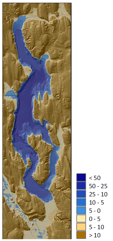
English: Bathymetric map of Lake Washington, Washington state, U.S., with depth in meters, and topographic map of surrounding areas
|
| ⧼wm-license-information-date⧽ | 2010 |
| ⧼wm-license-information-source⧽ | https://swfsc.noaa.gov/publications/CR/1978/7810.PDF |
| ⧼wm-license-information-author⧽ | Chris Chamberlin <chris.chamberlin@noaa.gov>, NOAA Center for Tsunami Research, Pacific Marine Environmental Laboratory |
| ⧼wm-license-information-other-versions⧽ |
ترخيص

|
تاريخ الملف
اضغط على زمن/تاريخ لرؤية الملف كما بدا في هذا الزمن.
| زمن/تاريخ | صورة مصغرة | الأبعاد | مستخدم | تعليق | |
|---|---|---|---|---|---|
| حالي | ★ مراجعة معتمدة 06:54، 28 نوفمبر 2023 | | 373 × 794 (407 كيلوبايت) | Pastakhov (نقاش | مساهمات) | Upload https://upload.wikimedia.org/wikipedia/commons/a/ab/Lake_Washington_bathymetry.png |
لا يمكنك استبدال هذا الملف.
وصلات
لا يوجد صفحات تصل لهذه الصورة.