ملف:Kirkpatrick Fleming Church - geograph.org.uk - 698604.jpg
لا توجد دقة أعلى متوفرة.
Kirkpatrick_Fleming_Church_-_geograph.org.uk_-_698604.jpg (640 × 480 بكسل حجم الملف: 90 كيلوبايت، نوع MIME: image/jpeg)
وصف قصير
| ⧼wm-license-information-description⧽ |
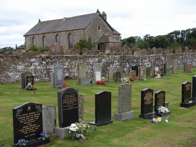
English: Kirkpatrick Fleming Church Kirkpatrick Fleming Parish Church has been substantially rebuilt since 1726 but retains earlier masonry including a bellcote of 1733. Image of the church taken from the cemetery (S section) and over the old graveyard.
The cemetery (E and S sections) contain seven war graves including 4 members of the British Honduras Forestry Unit.
|
| ⧼wm-license-information-date⧽ | 2005 |
| ⧼wm-license-information-source⧽ | From geograph.org.uk |
| ⧼wm-license-information-author⧽ | Chris Newman |
| ⧼wm-license-cc-attribution⧽ (قالب:I18n/Credit line) |
Chris Newman / Kirkpatrick Fleming Church / |
55°01′11″N 3°07′59″W / 55.01975°N 3.1330°W قالب:Object location
_heading:22)
ترخيص
تاريخ الملف
اضغط على زمن/تاريخ لرؤية الملف كما بدا في هذا الزمن.
| زمن/تاريخ | صورة مصغرة | الأبعاد | مستخدم | تعليق | |
|---|---|---|---|---|---|
| حالي | ★ مراجعة معتمدة 19:56، 24 ديسمبر 2023 | | 640 × 480 (90 كيلوبايت) | Pastakhov (نقاش | مساهمات) | Upload https://upload.wikimedia.org/wikipedia/commons/9/9e/Kirkpatrick_Fleming_Church_-_geograph.org.uk_-_698604.jpg |
لا يمكنك استبدال هذا الملف.
وصلات
لا يوجد صفحات تصل لهذه الصورة.