ملف:King's Barton area, Thatcher Rock and Ilsham, Torquay across Torbay - geograph.org.uk - 1047422.jpg
لا توجد دقة أعلى متوفرة.
King's_Barton_area,_Thatcher_Rock_and_Ilsham,_Torquay_across_Torbay_-_geograph.org.uk_-_1047422.jpg (640 × 409 بكسل حجم الملف: 43 كيلوبايت، نوع MIME: image/jpeg)
وصف قصير
| ⧼wm-license-information-description⧽ |
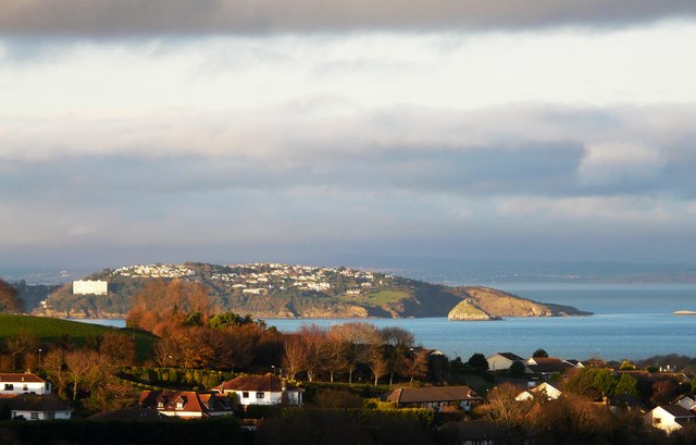
English: King's Barton area, Thatcher Rock and Ilsham, Torquay across Torbay This image was taken from the Hillhead area over the Guzzle Down area of Brixham. The King's Barton area of Brixham is in the foreground with the Ilsham area of Torquay across the other side of Torbay. The Ore Stone is at the extreme right of the picture. The extreme point of the mainland across the bay is Hope's Nose and in front of that is Thatcher Rock.
|
| ⧼wm-license-information-date⧽ | 2008 |
| ⧼wm-license-information-source⧽ | From geograph.org.uk |
| ⧼wm-license-information-author⧽ | Tom Jolliffe |
| ⧼wm-license-cc-attribution⧽ (قالب:I18n/Credit line) |
Tom Jolliffe / King's Barton area, Thatcher Rock and Ilsham, Torquay across Torbay / |
50°22′28″N 3°32′18″W / 50.37441°N 3.5383°W قالب:Object location
_heading:45)
ترخيص
تاريخ الملف
اضغط على زمن/تاريخ لرؤية الملف كما بدا في هذا الزمن.
| زمن/تاريخ | صورة مصغرة | الأبعاد | مستخدم | تعليق | |
|---|---|---|---|---|---|
| حالي | ★ مراجعة معتمدة 19:44، 24 أكتوبر 2023 | | 640 × 409 (43 كيلوبايت) | Pastakhov (نقاش | مساهمات) | Upload https://upload.wikimedia.org/wikipedia/commons/0/02/King%27s_Barton_area%2C_Thatcher_Rock_and_Ilsham%2C_Torquay_across_Torbay_-_geograph.org.uk_-_1047422.jpg |
لا يمكنك استبدال هذا الملف.
وصلات
لا يوجد صفحات تصل لهذه الصورة.