ملف:Karte - Kesselschlacht bei Vjasma 1941.png
حجم هذه المعاينة: 583 × 600 بكسل. البعد الآخر: 1٬047 × 1٬077 بكسل.
الملف الأصلي (1٬047 × 1٬077 بكسل حجم الملف: 333 كيلوبايت، نوع MIME: image/png)
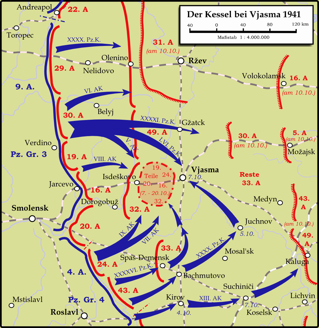
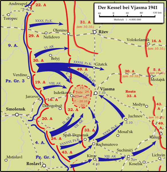
На карте ошибка, город "ГЖАТСК" находится не там. Там где его изобразили находится Новодугино, а Гжатск находится между Вязьмой и Можайском
وصف قصير
| ⧼wm-license-information-description⧽ |
English: Map showing the Battle near Vyazma (October 2nd — October 20th 1941) during the Second World War (1939—1945) at the Eastern Front. The map is created by Inkscape and is based on the Map 30 in the attachement of the book P.N. Pospelow (Hrsg.): Geschichte des Großen Vaterländischen Krieges der Sowjetunion, Bd.2, Berlin (Ost) 1963. The troop movements have been corrected.
Deutsch: Karte der Kesselschlacht im Raum Vjasma (2. Oktober — 20. Oktober 1941) während des Zweiten Weltkrieges (1939—1945) an der Ostfront. Die Karte wurde mit Inkscape erstellt und basiert auf Karte Nr.30 aus dem Anhang des Buches P.N. Pospelow (Hrsg.): Geschichte des Großen Vaterländischen Krieges der Sowjetunion, Bd.2, Berlin (Ost) 1963. Die Truppenbewegungen wurden jedoch korrigiert.
|
| ⧼wm-license-information-date⧽ | 2009 |
| ⧼wm-license-information-source⧽ | ⧼Wm-license-own-work⧽ |
| ⧼wm-license-information-author⧽ | Memnon335bc |
ترخيص
|

تاريخ الملف
اضغط على زمن/تاريخ لرؤية الملف كما بدا في هذا الزمن.
| زمن/تاريخ | صورة مصغرة | الأبعاد | مستخدم | تعليق | |
|---|---|---|---|---|---|
| حالي | ★ مراجعة معتمدة 03:09، 20 نوفمبر 2023 | | 1٬047 × 1٬077 (333 كيلوبايت) | Pastakhov (نقاش | مساهمات) | Upload https://upload.wikimedia.org/wikipedia/commons/4/44/Karte_-_Kesselschlacht_bei_Vjasma_1941.png |
لا يمكنك استبدال هذا الملف.
وصلات
لا يوجد صفحات تصل لهذه الصورة.