ملف:Josephinische Landaufnahme pg141.jpg

حجم هذه المعاينة: 800 × 534 بكسل. البعدان الآخران: 2٬560 × 1٬710 بكسل | 8٬359 × 5٬584 بكسل.
الملف الأصلي (8٬359 × 5٬584 بكسل حجم الملف: 22٫95 ميجابايت، نوع MIME: image/jpeg)
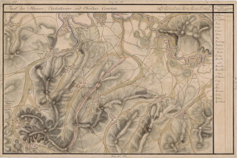
| Name shown on the map Nume din hartă |
Administrative unit Unitate administrativă |
Romanian name Numele românesc |
Hungarian name Numele unguresc |
German name Numele german |
Country today Ţara de astăzi |
|---|---|---|---|---|---|
| Maros Gese | Fehér megye Unterweißenburger Komitat Comitatul Alba de Jos |
Gheja | Marosgezse | Geschendorf | Romania |
| Maros Bogat | Torda megye Komitat Torda Comitatul Turda |
Bogata | Marosbogát | Romania | |
| Oroszi | Fehér megye | Orosia | Marosoroszi | Russendorf | Romania |
| Csintas | Fehér megye | Aţintiş | Cintos | Zinzendorf | Romania |
| Szent Jacob | Fehér megye | Sâniacob | Marosszentjakab | Romania | |
| Kutyfalva | Fehér megye | Cuci | Kutyfalva | Kokt | Romania |
| Datos | Torda megye | Dătăşeni | Marosdátos | Dalmesch | Romania |
| Lekentze | Torda megye | Lechinţa | Maroslekence | Lechnitz | Romania |
| Radnoth | Küküllõ megye Komitat Kokelburg Comitatul Târnava |
Iernut | Radnót | Radnuten | Romania |
| Csapo | Küküllõ megye | Cipău | Maroscsapó | Romania | |
| Olah Kotsárd | Küküllõ megye | Cucerdea | Oláhkocsárd | Romania | |
| Sállya | Küküllõ megye | Şeulia de Mureş | Oláhsályi | Salvey | Romania |
| Bord | Küküllõ megye | Bord | Bord | Borden, Borten | Romania |
| Deg | Küküllõ megye | Deag | Marosdég | Deck | Romania |
| Szélkut | Küküllõ megye | Sălcud | Szélkút | Blasenbrunn | Romania |
| Maros Peterlaka | Küküllõ megye | Petrilaca | Oláhpéterlaka | Petersheim | Romania |
| Istvánháza | Fehér megye | Iştihaza | Istvánháza | Stephanskirch | Romania |
| Bukkõs | Fehér megye | Bichiş | Magyarbükkös | Buchendorf | Romania |
| Ozd | Fehér megye | Ozd | Magyarózd | Thürendorf | Romania |
| Lándor vel Nándor | Fehér megye | Nandra | Lándor, Lándorlaka, Nándorlaka, Nándortelke | Weissdorf | Romania |
وصف قصير
| ⧼wm-license-information-description⧽ |
English: Grand Duchy of Transylvania, 1769-1773. Josephinische Landaufnahme pg.141 قالب:Ro
|
||
| ⧼wm-license-information-date⧽ | between 1769 and 1773 | ||
| ⧼wm-license-information-source⧽ | Österreichisches Staatsarchiv, Kriegsarchiv, B IX 715: Original-Aufnahmskarte des Grossfürtenthums Siebenbürgen. Geometrisch aufgenommen und bearbeitet in den Jahren 1769 bis 1773 unter der Direction des Obristen von Fabris, theils durch Officiere des grossen Feld-Generalstabes, theils auch von verschiedenen aus dem in Siebenbürgen bequartierten Regimentern zu diesem Geschäfte beigezogenen Individuen | ||
| ⧼wm-license-information-author⧽ | Historische Militärkarte der österreichisch-ungarischen Monarchie | ||
| ⧼wm-license-information-permission⧽ (⧼wm-license-information-permission-reusing-text⧽) |
|
Clickable Map of the Grand Duchy of Transylvania
تاريخ الملف
اضغط على زمن/تاريخ لرؤية الملف كما بدا في هذا الزمن.
| زمن/تاريخ | صورة مصغرة | الأبعاد | مستخدم | تعليق | |
|---|---|---|---|---|---|
| حالي | ★ مراجعة معتمدة 12:24، 29 نوفمبر 2023 | | 8٬359 × 5٬584 (22٫95 ميجابايت) | Pastakhov (نقاش | مساهمات) | Upload https://upload.wikimedia.org/wikipedia/commons/c/cb/Josephinische_Landaufnahme_pg141.jpg |
لا يمكنك استبدال هذا الملف.
وصلات
لا يوجد صفحات تصل لهذه الصورة.