ملف:Ice sheet in motion ESA349840.jpg
حجم هذه المعاينة: 363 × 599 بكسل. البعد الآخر: 2٬125 × 3٬507 بكسل.
الملف الأصلي (2٬125 × 3٬507 بكسل حجم الملف: 2٫26 ميجابايت، نوع MIME: image/jpeg)
وصف قصير
| ⧼wm-license-information-description⧽ |
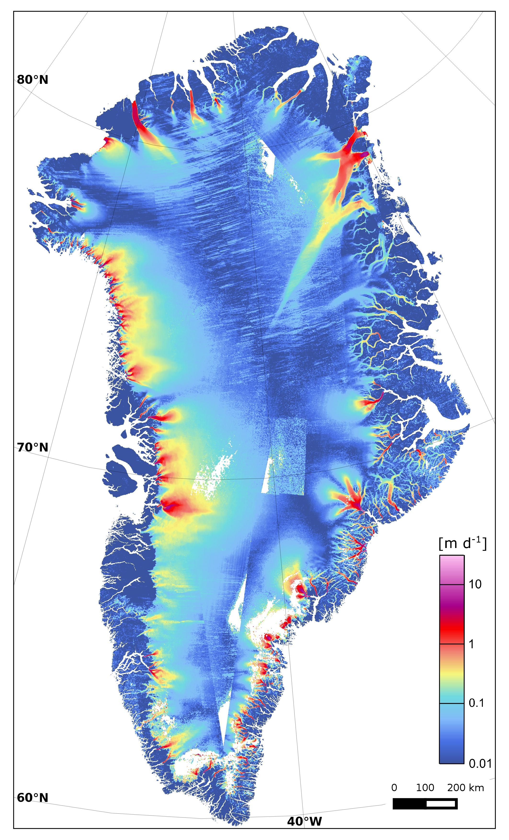
English: This map of Greenland ice sheet velocity was created using data from Sentinel-1A in January–March 2015 and complemented by the routine 12-day repeat acquisitions of the margins since June 2015. About 1200 radar scenes from the satellite’s wide-swath mode were used to produce the map, which clearly shows dynamic glacier outlets around the Greenland coast. In particular, the Zachariae Isstrom glacier in the northeast is changing rapidly, and recently reported as having become unmoored from a stabilising sill and now crumbling into the North Atlantic Ocean. (Colour scale in metres per day).
|
| ⧼wm-license-information-date⧽ | 2015 |
| ⧼wm-license-information-source⧽ | http://www.esa.int/spaceinimages/Images/2015/11/Ice_sheet_in_motion |
| ⧼wm-license-information-author⧽ | European Space Agency |
| ⧼wm-license-information-permission⧽ (⧼wm-license-information-permission-reusing-text⧽) |
Contains modified Copernicus Sentinel data (2015)/ENVEO/ESA CCI/FFG,CC BY-SA 3.0 IGO |
| Title | Ice sheet in motion |
| Mission | Sentinel-1 |
| Activity | Observing the Earth |
ترخيص
تاريخ الملف
اضغط على زمن/تاريخ لرؤية الملف كما بدا في هذا الزمن.
| زمن/تاريخ | صورة مصغرة | الأبعاد | مستخدم | تعليق | |
|---|---|---|---|---|---|
| حالي | ★ مراجعة معتمدة 00:51، 7 نوفمبر 2023 | | 2٬125 × 3٬507 (2٫26 ميجابايت) | Pastakhov (نقاش | مساهمات) | Upload https://upload.wikimedia.org/wikipedia/commons/6/6b/Ice_sheet_in_motion_ESA349840.jpg |
لا يمكنك استبدال هذا الملف.
وصلات
لا يوجد صفحات تصل لهذه الصورة.