ملف:Hutt River2.png

حجم هذه المعاينة: 455 × 599 بكسل. البعد الآخر: 1٬148 × 1٬511 بكسل.
الملف الأصلي (1٬148 × 1٬511 بكسل حجم الملف: 2٫06 ميجابايت، نوع MIME: image/png)
وصف قصير
| ⧼wm-license-information-description⧽ |
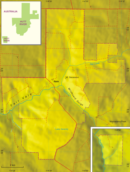
English: Map of the Principality of Hutt River
|
| ⧼wm-license-information-date⧽ | |
| ⧼wm-license-information-source⧽ | Own work, based on: Australian topographic map 1:250.000, Satelitte images from Google Earth, and maps from Hutt River web site (Location Map and Region Map) |
| ⧼wm-license-information-author⧽ | Aotearoa |
| ⧼wm-license-information-other-versions⧽ |
|

ترخيص
|

تاريخ الملف
اضغط على زمن/تاريخ لرؤية الملف كما بدا في هذا الزمن.
| زمن/تاريخ | صورة مصغرة | الأبعاد | مستخدم | تعليق | |
|---|---|---|---|---|---|
| حالي | ★ مراجعة معتمدة 10:10، 30 أكتوبر 2023 | | 1٬148 × 1٬511 (2٫06 ميجابايت) | Pastakhov (نقاش | مساهمات) | Upload https://upload.wikimedia.org/wikipedia/commons/2/26/Hutt_River2.png |
لا يمكنك استبدال هذا الملف.
وصلات
لا يوجد صفحات تصل لهذه الصورة.